Geographic Region: USA-HAWAII
Feature: MIDWAY ISLAND
|
Geographic Region: USA-HAWAII Feature: MIDWAY ISLAND |
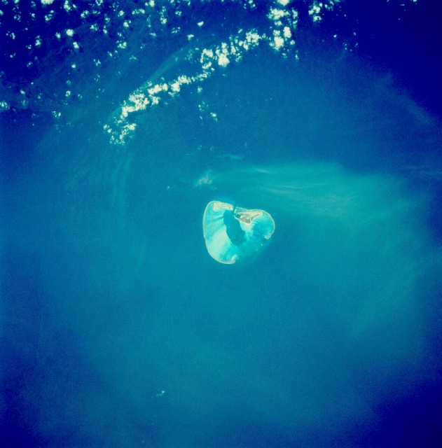 |
| STS055-82-63 Midway Island, Pacific Ocean May 1993 Midway Island, located in the central Pacific Ocean, is the subject of this near-vertical-looking photograph. Midway actually is made up of two islands, Sand and Eastern, each of which is surrounded by a coral reef. A lagoon is visible at the center of the island. The island covers an area of only 2 square miles (5 square kilometers). Midway is not incorporated into the state of Hawaii, but is administered by the U.S. Navy. No native population lives on the island--only a small staff of military personnel; note the military airport runways that can be seen in the photograph. The most famous inhabitants of the island are the numerous gooney birds. Midway is volcanic in origin, having been born nearly 70 million years ago as the Pacific crustal plate gradually drifted northwest over a hot spot--a source of magma far below the Earth's crust--where the big island of Hawaii now sits. As the island volcano gradually moved away from the hot spot, erosion began. The greatest portion of the original volcanic island of Midway has long since been eroded away. Midway Island is famous for the battle fought to the north of the island between Japanese and American Naval forces in June 1942. The battle was one of the decisive Allied victories of World War II. |
| Images: | All Available Images Low-Resolution 91k |
|
| Mission: | STS055 |
|
| Roll - Frame: | 82 - 63 |
|
| Geographical Name: | USA-HAWAII |
|
| Features: | MIDWAY ISLAND |
|
| Center Lat x Lon: | 28.0N x 177.5W |
|
| Film Exposure: | N | N=Normal exposure, U=Under exposed, O=Over exposed, F=out of Focus |
| Percentage of Cloud Cover-CLDP: | 5 |
|
| Camera:: | HB |
|
| Camera Tilt: | 11 | LO=Low Oblique, HO=High Oblique, NV=Near Vertical |
| Camera Focal Length: | 250 |
|
| Nadir to Photo Center Direction: | S | The direction from the nadir to the center point, N=North, S=South, E=East, W=West |
| Stereo?: | Y | Y=Yes there is an adjacent picture of the same area, N=No there isn't |
| Orbit Number: | 21 |
|
| Date: | 19930427 | YYYYMMDD |
| Time: | 210246 | GMT HHMMSS |
| Nadir Lat: | 28.5N |
Latitude of suborbital point of spacecraft |
| Nadir Lon: | 177.7W |
Longitude of suborbital point of spacecraft |
| Sun Azimuth: | 102 | Clockwise angle in degrees from north to the sun measured at the nadir point |
| Space Craft Altitude: | 163 | nautical miles |
| Sun Elevation: | 49 | Angle in degrees between the horizon and the sun, measured at the nadir point |
| Land Views: | ISLAND |
|
| Water Views: | OCEAN, LAGOON, REEF |
|
| Atmosphere Views: | |
|
| Man Made Views: | AIRPORT |
|
| City Views: | |
|
Photo is not associated with any sequences | ||
| NASA Home Page |
JSC Home Page |
JSC Digital Image Collection |
Earth Science & Remote Sensing |
|
This service is provided by the International Space Station program and the JSC Earth Science & Remote Sensing Unit, ARES Division, Exploration Integration Science Directorate.

|