
Geographic Region: USA-LOUISIANA
Feature: RED R., ATCHAFALAYA FORK
|
Geographic Region: USA-LOUISIANA Feature: RED R., ATCHAFALAYA FORK |
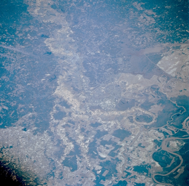 |
| STS055-081-059 Red River Valley, Louisiana, U.S.A. May 1993 This northwest-looking photograph of central Louisiana accentuates the complicated merging of the Red River, Mississippi River, and Atchafalaya River between Alexandria and Baton Rouge. Alexandria is discernible along an east meander of the Red River, which has a broad, northwest-southeast-aligned floodplain. Visible are several large meanders of the Mississippi River (lower right corner) and the Atchafalaya River to the west, the main channel of which can be traced northward to the southern edge of the Dismal Swamp. Numerous interconnecting channels and streams crisscross the flat, swampy landscape. Cultivated field patterns are visible on the elevated terrain (lower left corner). |
| Images: | All Available Images Low-Resolution 359k |
|
| Mission: | STS055 |
|
| Roll - Frame: | 81 - 59 |
|
| Geographical Name: | USA-LOUISIANA |
|
| Features: | RED R., ATCHAFALAYA FORK |
|
| Center Lat x Lon: | 31.5N x 92W |
|
| Film Exposure: | N | N=Normal exposure, U=Under exposed, O=Over exposed, F=out of Focus |
| Percentage of Cloud Cover-CLDP: | 0 |
|
| Camera:: | HB |
|
| Camera Tilt: | NV | LO=Low Oblique, HO=High Oblique, NV=Near Vertical |
| Camera Focal Length: | 250 |
|
| Nadir to Photo Center Direction: | NW | The direction from the nadir to the center point, N=North, S=South, E=East, W=West |
| Stereo?: | Y | Y=Yes there is an adjacent picture of the same area, N=No there isn't |
| Orbit Number: | 17 |
|
| Date: | 19930427 | YYYYMMDD |
| Time: | 150022 | GMT HHMMSS |
| Nadir Lat: | 28.5N |
Latitude of suborbital point of spacecraft |
| Nadir Lon: | 90.2W |
Longitude of suborbital point of spacecraft |
| Sun Azimuth: | 100 | Clockwise angle in degrees from north to the sun measured at the nadir point |
| Space Craft Altitude: | 163 | nautical miles |
| Sun Elevation: | 46 | Angle in degrees between the horizon and the sun, measured at the nadir point |
| Land Views: | FLOOD PLAIN, PLAIN |
|
| Water Views: | RIVER, SWAMP |
|
| Atmosphere Views: | |
|
| Man Made Views: | AGRICULTURE |
|
| City Views: | |
|
Photo is not associated with any sequences | ||
| NASA Home Page |
JSC Home Page |
JSC Digital Image Collection |
Earth Science & Remote Sensing |
|
This service is provided by the International Space Station program and the JSC Earth Science & Remote Sensing Unit, ARES Division, Exploration Integration Science Directorate.

|