Geographic Region: PACIFIC OCEAN I(S).
Feature: WAKE ISLAND
|
Geographic Region: PACIFIC OCEAN I(S). Feature: WAKE ISLAND |
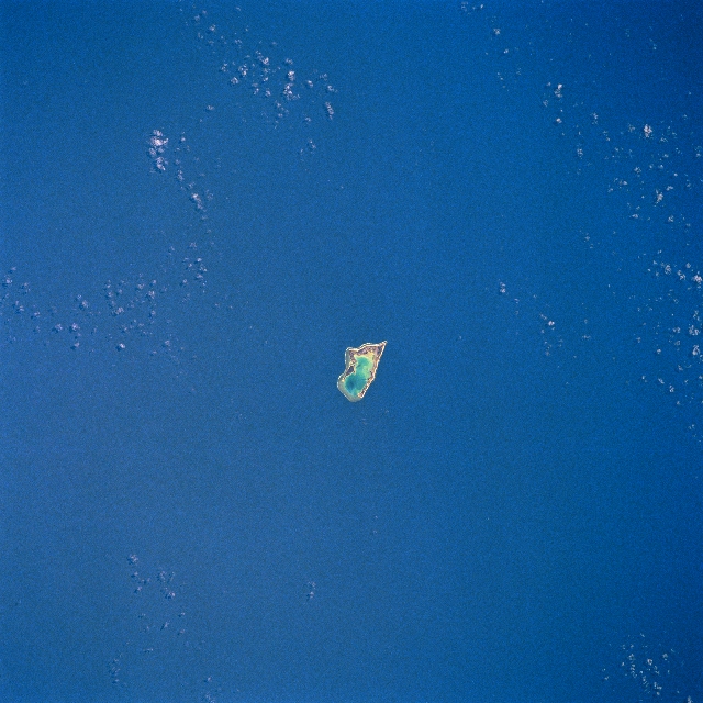 |
| STS055-080-063 Wake Island, Pacific Ocean May 1993 The nearly triangular-shaped Wake Island can be seen in this near-nadir view. Located in the Pacific Ocean east of the North Mariana Islands, the atoll is made up of three small coral islands built on an underwater volcano. The central lagoon is the former crater of the volcano and the three small islands are part of the rim. Wake Island is used as a military crossroad for ships and airplanes crossing the Pacific. All food, water, and other supplies for the United States Military Personnel living on the island are imported. The island is occasionally hit by typhoons. |
| Images: | All Available Images Low-Resolution 324k |
|
| Mission: | STS055 |
|
| Roll - Frame: | 80 - 63 |
|
| Geographical Name: | PACIFIC OCEAN I(S). |
|
| Features: | WAKE ISLAND |
|
| Center Lat x Lon: | 19.5N x 166.5E |
|
| Film Exposure: | N | N=Normal exposure, U=Under exposed, O=Over exposed, F=out of Focus |
| Percentage of Cloud Cover-CLDP: | 5 |
|
| Camera:: | HB |
|
| Camera Tilt: | 26 | LO=Low Oblique, HO=High Oblique, NV=Near Vertical |
| Camera Focal Length: | 250 |
|
| Nadir to Photo Center Direction: | SE | The direction from the nadir to the center point, N=North, S=South, E=East, W=West |
| Stereo?: | N | Y=Yes there is an adjacent picture of the same area, N=No there isn't |
| Orbit Number: | 39 |
|
| Date: | 19930429 | YYYYMMDD |
| Time: | 001837 | GMT HHMMSS |
| Nadir Lat: | 20.6N |
Latitude of suborbital point of spacecraft |
| Nadir Lon: | 165.8E |
Longitude of suborbital point of spacecraft |
| Sun Azimuth: | 124 | Clockwise angle in degrees from north to the sun measured at the nadir point |
| Space Craft Altitude: | 163 | nautical miles |
| Sun Elevation: | 80 | Angle in degrees between the horizon and the sun, measured at the nadir point |
| Land Views: | ISLAND, ATOLL |
|
| Water Views: | LAGOON |
|
| Atmosphere Views: | |
|
| Man Made Views: | |
|
| City Views: | |
|
Photo is not associated with any sequences | ||
| NASA Home Page |
JSC Home Page |
JSC Digital Image Collection |
Earth Science & Remote Sensing |
|
This service is provided by the International Space Station program and the JSC Earth Science & Remote Sensing Unit, ARES Division, Exploration Integration Science Directorate.

|