
Geographic Region: PAKISTAN
Feature: COASTLINE, MAKRAN RANGE
|
Geographic Region: PAKISTAN Feature: COASTLINE, MAKRAN RANGE |
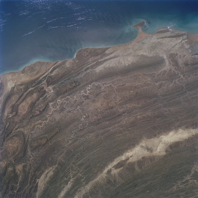 |
| STS055-077-069 Makran Mountains, Pakistan May 1993 The impact of the Indian plate colliding with the Eurasian plate is captured in this synoptic image of the large-scale crustal deformation in southwest Pakistan adjacent to the Arabian Sea. This type of view shows the result of the tremendous tectonic forces that have shaped the rugged mountainous landscape of western Pakistan. Looking at the folding and bending of the Makran Coast Range and the Central Makran Coast Range with the intervening arid valleys, hills, and plateaus the result of plate tectonics on this part of the world is striking and dramatic. The ridgelines and peaks of the mountainous terrain range from 3000 feet (915 meters) to 4500 feet (1370 meters) above sea level. The structure-controlled drainage pattern (light-colored, meandering lines), especially of the Hingol River and its tributaries (lower left quadrant), parallels the multi folded mountains. In a few places the ephemeral streams have continually cut through the mountains as the uplifting and folding processes progressed to maintain drainage channels (southward) into the Arabian Sea. The elongated, highly reflective feature (bottom right) is a large dry lake (salt flat) that is located in an isolated valley. |
| Images: | All Available Images Low-Resolution 308k |
|
| Mission: | STS055 |
|
| Roll - Frame: | 77 - 69 |
|
| Geographical Name: | PAKISTAN |
|
| Features: | COASTLINE, MAKRAN RANGE |
|
| Center Lat x Lon: | 26.5N x 65.5E |
|
| Film Exposure: | N | N=Normal exposure, U=Under exposed, O=Over exposed, F=out of Focus |
| Percentage of Cloud Cover-CLDP: | 5 |
|
| Camera:: | HB |
|
| Camera Tilt: | 31 | LO=Low Oblique, HO=High Oblique, NV=Near Vertical |
| Camera Focal Length: | 100 |
|
| Nadir to Photo Center Direction: | E | The direction from the nadir to the center point, N=North, S=South, E=East, W=West |
| Stereo?: | N | Y=Yes there is an adjacent picture of the same area, N=No there isn't |
| Orbit Number: | 27 |
|
| Date: | 19930428 | YYYYMMDD |
| Time: | 060946 | GMT HHMMSS |
| Nadir Lat: | 26.1N |
Latitude of suborbital point of spacecraft |
| Nadir Lon: | 63.9E |
Longitude of suborbital point of spacecraft |
| Sun Azimuth: | 114 | Clockwise angle in degrees from north to the sun measured at the nadir point |
| Space Craft Altitude: | 163 | nautical miles |
| Sun Elevation: | 65 | Angle in degrees between the horizon and the sun, measured at the nadir point |
| Land Views: | MOUNTAIN, VALLEY |
|
| Water Views: | RIVER, SEA |
|
| Atmosphere Views: | |
|
| Man Made Views: | |
|
| City Views: | |
|
Photo is not associated with any sequences | ||
| NASA Home Page |
JSC Home Page |
JSC Digital Image Collection |
Earth Science & Remote Sensing |
|
This service is provided by the International Space Station program and the JSC Earth Science & Remote Sensing Unit, ARES Division, Exploration Integration Science Directorate.

|