
Geographic Region: USA-TEXAS
Feature: GALVESTON BAY, HOUSTON
|
Geographic Region: USA-TEXAS Feature: GALVESTON BAY, HOUSTON |
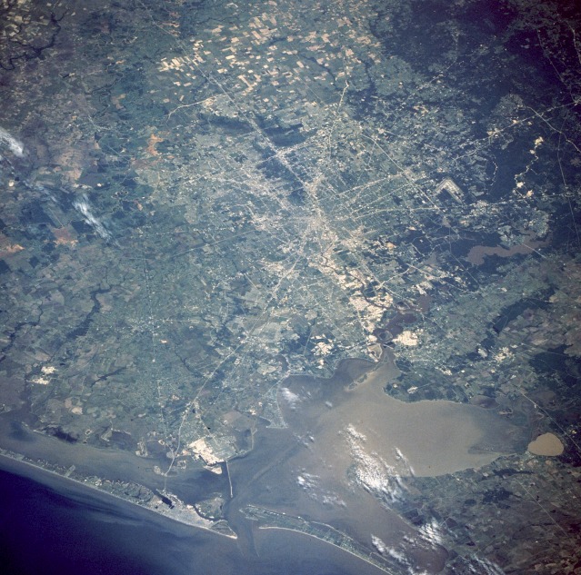 |
| STS055-71-43 Houston Metropolitan Area, Texas, U.S.A. April 1993 The greater Houston metropolitan area is visible in this low-oblique, northwest-looking photograph. The city is highlighted by an obvious radial pattern of numerous freeways and interstate highways leading into and out of the largest city in Texas. Interstate Highway 45 is the major artery connecting Houston with Galveston Island. The approximate distance from downtown Houston to downtown Galveston is 50 miles (80 kilometers). V-shaped Houston Intercontinental Airport can be seen on the city's north side. East of the airport is Lake Houston, source of the city's drinking water. South of Lake Houston, beginning near the downtown area of Houston, is the Houston Ship Channel, which extends to Galveston. Galveston Island is the barrier island southeast of Houston. The city of Galveston can be seen as a grayish area concentrated on the east end of the island. Galveston Bay is shallow--approximately 12 feet (4 meters) deep. The Houston Ship Channel is dredged frequently to facilitate major shipping into Houston, the third largest port in the United States. Texas City, a major site for petrochemical processing, is seen as the highly reflective area on the mainland between the Texas City Dike and the Interstate Highway 45 bridge over the bay to Galveston. |
| Images: | All Available Images Low-Resolution 166k |
|
| Mission: | STS055 |
|
| Roll - Frame: | 71 - 43 |
|
| Geographical Name: | USA-TEXAS |
|
| Features: | GALVESTON BAY, HOUSTON |
|
| Center Lat x Lon: | 29.5N x 95W |
|
| Film Exposure: | N | N=Normal exposure, U=Under exposed, O=Over exposed, F=out of Focus |
| Percentage of Cloud Cover-CLDP: | 5 |
|
| Camera:: | HB |
|
| Camera Tilt: | 48 | LO=Low Oblique, HO=High Oblique, NV=Near Vertical |
| Camera Focal Length: | 250 |
|
| Nadir to Photo Center Direction: | NW | The direction from the nadir to the center point, N=North, S=South, E=East, W=West |
| Stereo?: | Y | Y=Yes there is an adjacent picture of the same area, N=No there isn't |
| Orbit Number: | 2 |
|
| Date: | 19930426 | YYYYMMDD |
| Time: | 162748 | GMT HHMMSS |
| Nadir Lat: | 28.1N |
Latitude of suborbital point of spacecraft |
| Nadir Lon: | 92.3W |
Longitude of suborbital point of spacecraft |
| Sun Azimuth: | 117 | Clockwise angle in degrees from north to the sun measured at the nadir point |
| Space Craft Altitude: | 163 | nautical miles |
| Sun Elevation: | 63 | Angle in degrees between the horizon and the sun, measured at the nadir point |
| Land Views: | COAST, FOREST, ISLAND, PLAIN |
|
| Water Views: | CHANNEL, BAY, LAKE, RESERVOIR, SEDIMENT |
|
| Atmosphere Views: | |
|
| Man Made Views: | URBAN AREA, AIRPORT, AGRICULTURE |
|
| City Views: | HOUSTON, GALVESTON |
|
Photo is not associated with any sequences | ||
| NASA Home Page |
JSC Home Page |
JSC Digital Image Collection |
Earth Science & Remote Sensing |
|
This service is provided by the International Space Station program and the JSC Earth Science & Remote Sensing Unit, ARES Division, Exploration Integration Science Directorate.

|