
Geographic Region: USA-FLORIDA
Feature: TAMPA BAY AREA
|
Geographic Region: USA-FLORIDA Feature: TAMPA BAY AREA |
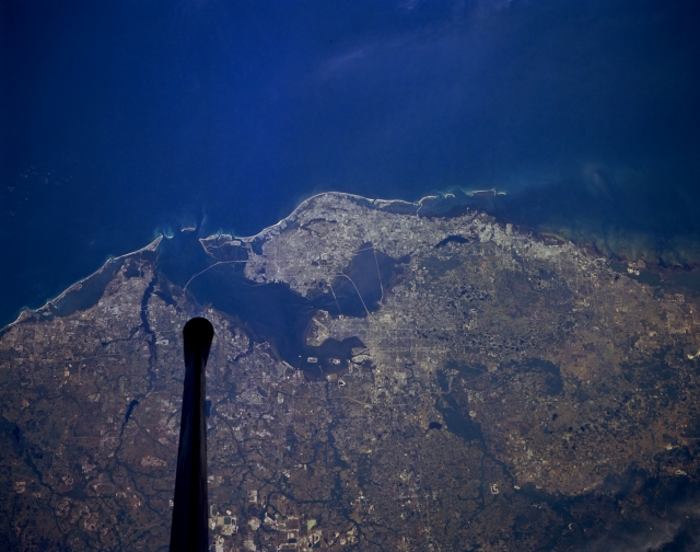 |
| STS055-152A-041 Tampa Bay, Florida, U.S.A. May 1993 The blue Gulf of Mexico contrasts sharply with the reflective sandy beaches along this section of west-central Florida. Crossing Tampa Bay are bridges that provide key land links between the major urban areas of Bradenton, Clearwater, Saint Petersburg, and Tampa. The short Manatee River travels across the flat landscape and empties into southern Tampa Bay. The highly reflective features (bottom center) appear to be limestone quarries. |
| Images: | All Available Images Low-Resolution 238k |
|
| Mission: | STS055 |
|
| Roll - Frame: | 152A - 41 |
|
| Geographical Name: | USA-FLORIDA |
|
| Features: | TAMPA BAY AREA |
|
| Center Lat x Lon: | 28.0N x 82.5W |
|
| Film Exposure: | N | N=Normal exposure, U=Under exposed, O=Over exposed, F=out of Focus |
| Percentage of Cloud Cover-CLDP: | 0 |
|
| Camera:: | LH |
|
| Camera Tilt: | 26 | LO=Low Oblique, HO=High Oblique, NV=Near Vertical |
| Camera Focal Length: | 250 |
|
| Nadir to Photo Center Direction: | W | The direction from the nadir to the center point, N=North, S=South, E=East, W=West |
| Stereo?: | N | Y=Yes there is an adjacent picture of the same area, N=No there isn't |
| Orbit Number: | 64 |
|
| Date: | 19930430 | YYYYMMDD |
| Time: | 134842 | GMT HHMMSS |
| Nadir Lat: | 27.7N |
Latitude of suborbital point of spacecraft |
| Nadir Lon: | 81.2W |
Longitude of suborbital point of spacecraft |
| Sun Azimuth: | 93 | Clockwise angle in degrees from north to the sun measured at the nadir point |
| Space Craft Altitude: | 164 | nautical miles |
| Sun Elevation: | 39 | Angle in degrees between the horizon and the sun, measured at the nadir point |
| Land Views: | PLAIN |
|
| Water Views: | BAY, GULF |
|
| Atmosphere Views: | |
|
| Man Made Views: | URBAN AREA, MINING |
|
| City Views: | |
|
Photo is not associated with any sequences | ||
| NASA Home Page |
JSC Home Page |
JSC Digital Image Collection |
Earth Science & Remote Sensing |
|
This service is provided by the International Space Station program and the JSC Earth Science & Remote Sensing Unit, ARES Division, Exploration Integration Science Directorate.

|