Geographic Region: SOMALIA
Feature: HORN OF AFRICA, COAST
|
Geographic Region: SOMALIA Feature: HORN OF AFRICA, COAST |
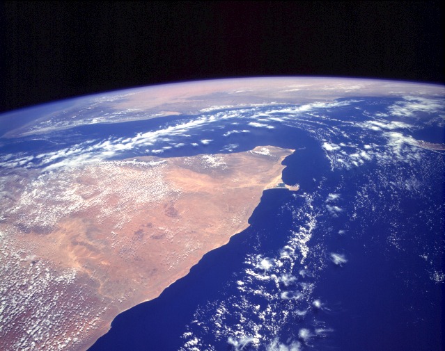 |
| STS055-151A-120 Horn of Africa, Somalia May 1993 The orange and tan colors of this high-oblique photograph of the Horn of Africa indicate an arid-to-semiarid landscape in the northern half of the east African country of Somalia. Except in the darker areas where thicker vegetation can be found (usually on the elevated areas), most of the vegetation in this part of Somalia is shrub brush and grasslands. Although most of this part of Somalia consists of a low, featureless plateau that tilts gradually southeastward from Ethiopia toward the Indian Ocean, the country does have a series of low, rugged mountains along its northern coast, adjacent to the Gulf of Aden. The general climate of this region features hot temperatures and scarce, irregular rainfall. Two distinct drainage basins are characterized by lighter colors--the Nugaaleed Valley along the western side of the photograph and the other watershed trending toward the Hafun Peninsula, the tombolo along the east coast of Somalia. The southern extent of the Saudi Arabian Peninsula is visible north across the Gulf of Aden. STS-55 Earth observation taken aboard Columbia, Orbiter Vehicle (OV) 102, shows Somalia, with the Gulf of Aden and South Yemen toward the north (top) and the Indian Ocean to the east (right). This LINHOF photograph provides a synoptic view of the Sanaag and Bari provinces. Clouds accentuate the escarpment running across the northern coast. Cape Guardafui, the tip of the Horn of Africa, is traditionally taken as the easternmost point of Africa. The strange-shaped promontory immediately south is about 0.1 degree farther east, however. |
| Images: | All Available Images Low-Resolution 113k |
|
| Mission: | STS055 |
|
| Roll - Frame: | 151A - 120 |
|
| Geographical Name: | SOMALIA |
|
| Features: | HORN OF AFRICA, COAST |
|
| Center Lat x Lon: | 10.0N x 50.0E |
|
| Film Exposure: | N | N=Normal exposure, U=Under exposed, O=Over exposed, F=out of Focus |
| Percentage of Cloud Cover-CLDP: | 10 |
|
| Camera:: | LH |
|
| Camera Tilt: | HO | LO=Low Oblique, HO=High Oblique, NV=Near Vertical |
| Camera Focal Length: | 90 |
|
| Nadir to Photo Center Direction: | N | The direction from the nadir to the center point, N=North, S=South, E=East, W=West |
| Stereo?: | N | Y=Yes there is an adjacent picture of the same area, N=No there isn't |
| Orbit Number: | 92 |
|
| Date: | 19930502 | YYYYMMDD |
| Time: | 081231 | GMT HHMMSS |
| Nadir Lat: | 6.1N |
Latitude of suborbital point of spacecraft |
| Nadir Lon: | 51.3E |
Longitude of suborbital point of spacecraft |
| Sun Azimuth: | 26 | Clockwise angle in degrees from north to the sun measured at the nadir point |
| Space Craft Altitude: | 163 | nautical miles |
| Sun Elevation: | 80 | Angle in degrees between the horizon and the sun, measured at the nadir point |
| Land Views: | COAST, PENINSULA, DESERT, CAPE |
|
| Water Views: | OCEAN, GULF, RIVER |
|
| Atmosphere Views: | |
|
| Man Made Views: | |
|
| City Views: | |
|
Photo is not associated with any sequences | ||
| NASA Home Page |
JSC Home Page |
JSC Digital Image Collection |
Earth Science & Remote Sensing |
|
This service is provided by the International Space Station program and the JSC Earth Science & Remote Sensing Unit, ARES Division, Exploration Integration Science Directorate.

|