Geographic Region: BRAZIL
Feature: POINT BALEIA, CARAVELAS
|
Geographic Region: BRAZIL Feature: POINT BALEIA, CARAVELAS |
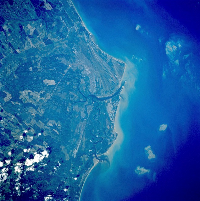 |
| STS054-086-001 Caravelas, Bahia, Brazil January 1993 This rural Brazilian coastal area is designated as an Atlantic rain forest, where annual precipitation usually exceeds 80 inches (200 centimeters). The general greenness of the vegetated cover supports the classification of a humid equatorial climate with no specific dry season. Barely visible are intersecting runways of a local airport approximately 5 miles (8 kilometers) north of the small town of Caravelas, north of the larger river estuary near the center of the photograph. Eastward toward the coast are numerous ancient beach terraces (parallel, striated lines). Two highly reflective, linear features, which are probably improved highways, traverse the coastal plains and connect interior cities with this small port city. The lighter field patterns are possibly large sugarcane plantations. The vegetated floodplain of the Alcobaca River is barely visible near the northern edge of the photograph. Cape Baleia (17.5N, 39.0W), on the north central coast of Brazil illustrates a good example of multiple coastal sand spits. Over a several thousand year time period, shifting regimes of wave and current patterns have piled up sand onto a series of beach ridges and tidal lagoons. Offshore, several prominent reefs and sandbanks can be seen paralleling the coast. The largest is the Recife da Pedra Grande (Big Rocks Reef). |
| Images: | All Available Images Low-Resolution 131k |
|
| Mission: | STS054 |
|
| Roll - Frame: | 86 - 1 |
|
| Geographical Name: | BRAZIL |
|
| Features: | POINT BALEIA, CARAVELAS |
|
| Center Lat x Lon: | 17.5S x 39W |
|
| Film Exposure: | N | N=Normal exposure, U=Under exposed, O=Over exposed, F=out of Focus |
| Percentage of Cloud Cover-CLDP: | 5 |
|
| Camera:: | HB |
|
| Camera Tilt: | 15 | LO=Low Oblique, HO=High Oblique, NV=Near Vertical |
| Camera Focal Length: | 250 |
|
| Nadir to Photo Center Direction: | E | The direction from the nadir to the center point, N=North, S=South, E=East, W=West |
| Stereo?: | N | Y=Yes there is an adjacent picture of the same area, N=No there isn't |
| Orbit Number: | 51 |
|
| Date: | 19930116 | YYYYMMDD |
| Time: | 180124 | GMT HHMMSS |
| Nadir Lat: | 17.6S |
Latitude of suborbital point of spacecraft |
| Nadir Lon: | 39.7W |
Longitude of suborbital point of spacecraft |
| Sun Azimuth: | 258 | Clockwise angle in degrees from north to the sun measured at the nadir point |
| Space Craft Altitude: | 163 | nautical miles |
| Sun Elevation: | 44 | Angle in degrees between the horizon and the sun, measured at the nadir point |
| Land Views: | COAST, PLAIN |
|
| Water Views: | OCEAN, RIVER, SEDIMENT |
|
| Atmosphere Views: | |
|
| Man Made Views: | |
|
| City Views: | |
|
Photo is not associated with any sequences | ||
| NASA Home Page |
JSC Home Page |
JSC Digital Image Collection |
Earth Science & Remote Sensing |
|
This service is provided by the International Space Station program and the JSC Earth Science & Remote Sensing Unit, ARES Division, Exploration Integration Science Directorate.

|