Geographic Region: LESSER ANTILLES
Feature: ST. CROIX
|
Geographic Region: LESSER ANTILLES Feature: ST. CROIX |
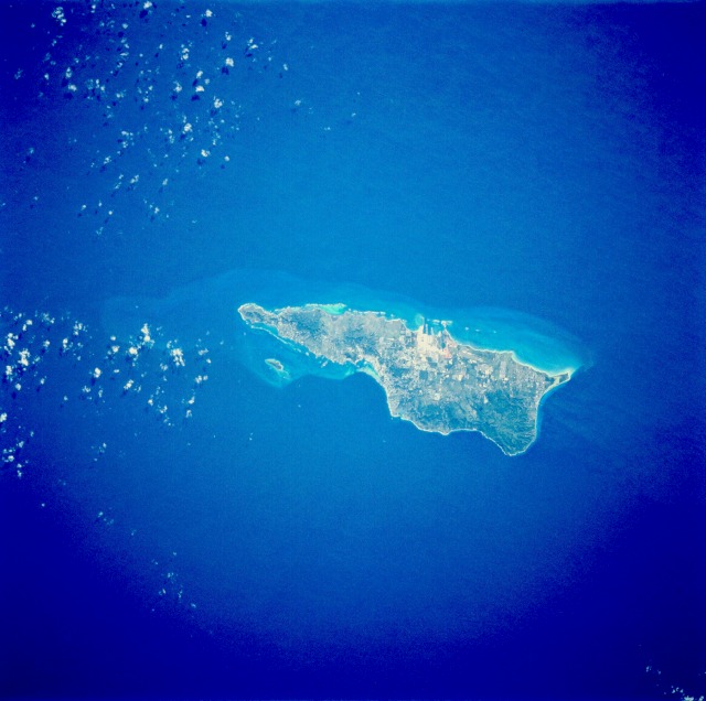 |
| STS054-74-49 Saint Croix, Virgin Islands of the United States January 1993 Saint Croix, largest of the Virgin Islands, is visible in this near-vertical photograph. Saint Croix, covering 80 square miles (more than 200 square kilometers), is of volcanic origin and is characterized by rugged slopes that rise abruptly from the sea. Most of the rugged hills are on the north and northwest sides of the island (dark green area), with the highest elevation approximately 1170 feet (350 meters) above sea level. The island of Saint Croix was discovered in 1493 by Christopher Columbus. The major city of Christiansted is located near the center of the northern coast. Large pasturelands are visible along the southwest coast. Tourism is the island's major industry; the petroleum processing and chemical industries are also important in the island's economy. St. Croix (17.5N, 65.0W) is the largest and most industrialized of the U.S. Virgin Islands. The large complex in the middle of the south shore is the world's largest petroleum refinery and the main city, Christiansted, is just across the island on the north shore. The reefs around the eastern end of St. Croix are preserved as a submarine national park: Buck Island Reef National Park, around the small island off the NE shore. |
| Images: | All Available Images Low-Resolution 91k |
|
| Mission: | STS054 |
|
| Roll - Frame: | 74 - 49 |
|
| Geographical Name: | LESSER ANTILLES |
|
| Features: | ST. CROIX |
|
| Center Lat x Lon: | 17.5N x 65W |
|
| Film Exposure: | N | N=Normal exposure, U=Under exposed, O=Over exposed, F=out of Focus |
| Percentage of Cloud Cover-CLDP: | 5 |
|
| Camera:: | HB |
|
| Camera Tilt: | 27 | LO=Low Oblique, HO=High Oblique, NV=Near Vertical |
| Camera Focal Length: | 250 |
|
| Nadir to Photo Center Direction: | SW | The direction from the nadir to the center point, N=North, S=South, E=East, W=West |
| Stereo?: | N | Y=Yes there is an adjacent picture of the same area, N=No there isn't |
| Orbit Number: | 18 |
|
| Date: | 19930114 | YYYYMMDD |
| Time: | 155725 | GMT HHMMSS |
| Nadir Lat: | 18.2N |
Latitude of suborbital point of spacecraft |
| Nadir Lon: | 63.8W |
Longitude of suborbital point of spacecraft |
| Sun Azimuth: | 170 | Clockwise angle in degrees from north to the sun measured at the nadir point |
| Space Craft Altitude: | 166 | nautical miles |
| Sun Elevation: | 50 | Angle in degrees between the horizon and the sun, measured at the nadir point |
| Land Views: | ISLAND, FOREST, HILL |
|
| Water Views: | SEA, OCEAN |
|
| Atmosphere Views: | |
|
| Man Made Views: | AGRICULTURE |
|
| City Views: | |
|
Photo is not associated with any sequences | ||
| NASA Home Page |
JSC Home Page |
JSC Digital Image Collection |
Earth Science & Remote Sensing |
|
This service is provided by the International Space Station program and the JSC Earth Science & Remote Sensing Unit, ARES Division, Exploration Integration Science Directorate.

|