Geographic Region: NIGER
Feature: TCHIGAI PLAT., MARZUQ D.
|
Geographic Region: NIGER Feature: TCHIGAI PLAT., MARZUQ D. |
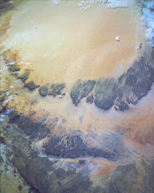 |
| STS054-152-189 Marzuq Desert, Libya January 1993 The Marzuq Desert is located in the southwestern corner of Libya and is made up of the Idehan Marzuq (sandy desert) and the Hammadat Marzuq (rocky desert). The Idehan Marzuq, visible in the eastern third of this photograph, covers approximately 36 000 square miles (58 000 square kilometers). This sandy desert has two types of sand dunes--linear dunes to the south-southeast and crescentric, compound dunes to the west-northwest. Most of the reddish eolian sand in the Marzuq Desert was transported from the volcanic area of the highland region in the northeast, principally from sources lying northeastward toward the Gulf of Sidra and northeast Libya. The Hammadat Marzuq (rocky desert), with eroded, darker bedrock outcrops (aligned north-south), lies west and northwest of the sandy desert. Several wadis (watercourses or dry riverbeds) are visible in the bedrock outcrops. The western half of the photograph is a mixture of exposed bedrock outcrops (dark surfaces) and an assortment of sand dunes. The dark, small, rectangular-shaped area near the northeastern corner of the Idehan Marzuq is a series of circular (center-pivot) irrigation plots that are used to grow crops in the Libyan desert. This near vertical view of the Murzuk Sand Sea, Sahara Desert, Libya (22.5N, 13.0E) shows the very diverse landscape that is part of the great Sahara Desert of North Africa. The vast expanse of sand dunes known as the Murzuk sand Sea of Libya and the adjacent rock outcrops support little human habitation. In fact, the tiny village of Murzuk with its center pivot, swing arm irrigated agriculture complex is the only sign of life in the region. |
| Images: | All Available Images Low-Resolution 104k |
|
| Mission: | STS054 |
|
| Roll - Frame: | 152 - 189 |
|
| Geographical Name: | NIGER |
|
| Features: | TCHIGAI PLAT., MARZUQ D. |
|
| Center Lat x Lon: | 22.5N x 13.0E |
|
| Film Exposure: | N | N=Normal exposure, U=Under exposed, O=Over exposed, F=out of Focus |
| Percentage of Cloud Cover-CLDP: | 5 |
|
| Camera:: | LH |
|
| Camera Tilt: | LO | LO=Low Oblique, HO=High Oblique, NV=Near Vertical |
| Camera Focal Length: | 250 |
|
| Nadir to Photo Center Direction: | The direction from the nadir to the center point, N=North, S=South, E=East, W=West |
|
| Stereo?: | Y | Y=Yes there is an adjacent picture of the same area, N=No there isn't |
| Orbit Number: | |
|
| Date: | 199301__ | YYYYMMDD |
| Time: | GMT HHMMSS |
|
| Nadir Lat: | N |
Latitude of suborbital point of spacecraft |
| Nadir Lon: | E |
Longitude of suborbital point of spacecraft |
| Sun Azimuth: | Clockwise angle in degrees from north to the sun measured at the nadir point |
|
| Space Craft Altitude: | nautical miles |
|
| Sun Elevation: | Angle in degrees between the horizon and the sun, measured at the nadir point |
|
| Land Views: | DESERT, DUNE, ESCARPMENT, PLATEAU |
|
| Water Views: | |
|
| Atmosphere Views: | |
|
| Man Made Views: | |
|
| City Views: | |
|
Photo is not associated with any sequences | ||
| NASA Home Page |
JSC Home Page |
JSC Digital Image Collection |
Earth Science & Remote Sensing |
|
This service is provided by the International Space Station program and the JSC Earth Science & Remote Sensing Unit, ARES Division, Exploration Integration Science Directorate.

|