Geographic Region: ZIMBABWE
Feature: GREAT DIKE
|
Geographic Region: ZIMBABWE Feature: GREAT DIKE |
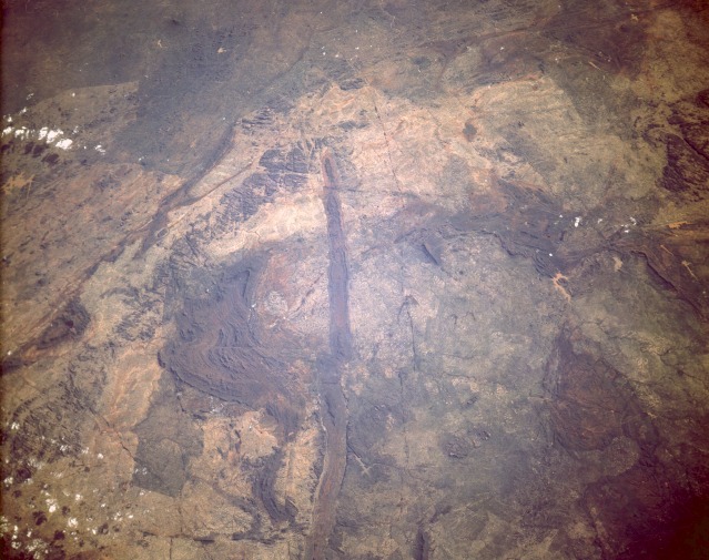 |
| STS054-152-016 Great Dike, Zimbabwe January 1993 The Great Dike of Zimbabwe is a linear geological feature that is easily recognizable running 300 miles (483 kilometers) north-south through the midsection of Zimbabwe. This photograph shows only the southernmost extent of the Great Dike. The highly mineralized composition of the dike (igneous rock) makes this an important economic region for Zimbabwe. Copper, asbestos, chromium, gold, and platinum are some of the minerals that make up the strategic mineral reserves found throughout this region. Some of the lighter brown areas in this photograph are large areas of overgrazed "tribal trust lands" that are scattered throughout Zimbabwe. There is also visual evidence that east-west surface displacement (faulting) has occurred at several points along the Great Dike. Much narrower, paralleling mineralized veins observed east and west of the Great Dike exhibit the same horizontal displacements as the much broader dike. The Great Dike of Zimbabwe (17.5S, 31.5E) bisects the entire length of Zimbabwae in southern Africa and is one of the prominent visual features easily recognized from low orbit. The volcanic rocks which make up the dike are about 1.2 billion years old and are rich in chromite and platinum which are mined from it. The straight line of the dike is offset in places by faults which are often occupied by streams flowing through the fractures. |
| Images: | All Available Images Low-Resolution 116k |
|
| Mission: | STS054 |
|
| Roll - Frame: | 152 - 16 |
|
| Geographical Name: | ZIMBABWE |
|
| Features: | GREAT DIKE |
|
| Center Lat x Lon: | 17.5S x 31.5E |
|
| Film Exposure: | N | N=Normal exposure, U=Under exposed, O=Over exposed, F=out of Focus |
| Percentage of Cloud Cover-CLDP: | 5 |
|
| Camera:: | LH |
|
| Camera Tilt: | LO | LO=Low Oblique, HO=High Oblique, NV=Near Vertical |
| Camera Focal Length: | 250 |
|
| Nadir to Photo Center Direction: | The direction from the nadir to the center point, N=North, S=South, E=East, W=West |
|
| Stereo?: | N | Y=Yes there is an adjacent picture of the same area, N=No there isn't |
| Orbit Number: | |
|
| Date: | 199301__ | YYYYMMDD |
| Time: | GMT HHMMSS |
|
| Nadir Lat: | N |
Latitude of suborbital point of spacecraft |
| Nadir Lon: | E |
Longitude of suborbital point of spacecraft |
| Sun Azimuth: | Clockwise angle in degrees from north to the sun measured at the nadir point |
|
| Space Craft Altitude: | nautical miles |
|
| Sun Elevation: | Angle in degrees between the horizon and the sun, measured at the nadir point |
|
| Land Views: | FAULT, ESCARPMENT, PLATEAU |
|
| Water Views: | |
|
| Atmosphere Views: | |
|
| Man Made Views: | AGRICULTURE, MINING |
|
| City Views: | |
|
Photo is not associated with any sequences | ||
| NASA Home Page |
JSC Home Page |
JSC Digital Image Collection |
Earth Science & Remote Sensing |
|
This service is provided by the International Space Station program and the JSC Earth Science & Remote Sensing Unit, ARES Division, Exploration Integration Science Directorate.

|