Geographic Region: MOZAMBIQUE
Feature: LOURENCO MARQUES BAY
|
Geographic Region: MOZAMBIQUE Feature: LOURENCO MARQUES BAY |
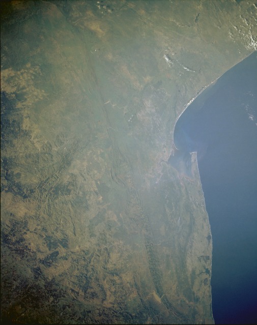 |
| STS054-151-023 Southern Mozambique and Swaziland January 1993 A striking topographic feature in this synoptic, low-oblique photograph is the prominent north-south-oriented Lebombo Mountains, whose elevations average approximately 2000 feet (610 meters). Known as the Lebombo monocline, its volcanic rocks are bounded by faults on the west side of the range, and it gradually dips eastward toward the Indian Ocean. Most of the fairly broad coast plain consists of low-lying, swampy terrain and many poorly drained lakes. Maputo, the capital city of Mozambique with a population of more than 2 million, is located on the west side of Maputo Bay, the large bay along the southern coast of Mozambique. (Refer to STS-032-074-024 for a more detailed description of the Maputo area.) The Pongola River, the major river that drains the coastal plains south of Maputo Bay, and a small sediment plume are visible south of the bay. Swaziland, one of southern Africa's smallest independent countries, lies immediately west of the Lebombo Mountains, which form the boundary between eastern Swaziland and Mozambique. Farther west appear the northeast-southwest-trending Barberton Mountains of South Africa's Transvaal. South Africa forms Swaziland's north, west, and south boundaries. Because rainfall amounts increase toward the western, higher elevations of Swaziland, the high veld (large solid green area) in western Swaziland receives 45 to 75 inches (110 to 190 centimeters) of annual rainfall, thereby promoting a forest industry of mainly pines and eucalyptus trees. |
| Images: | All Available Images Low-Resolution 77k |
|
| Mission: | STS054 |
|
| Roll - Frame: | 151 - 23 |
|
| Geographical Name: | MOZAMBIQUE |
|
| Features: | LOURENCO MARQUES BAY |
|
| Center Lat x Lon: | 26S x 33.0E |
|
| Film Exposure: | N | N=Normal exposure, U=Under exposed, O=Over exposed, F=out of Focus |
| Percentage of Cloud Cover-CLDP: | 5 |
|
| Camera:: | LH |
|
| Camera Tilt: | LO | LO=Low Oblique, HO=High Oblique, NV=Near Vertical |
| Camera Focal Length: | 90 |
|
| Nadir to Photo Center Direction: | The direction from the nadir to the center point, N=North, S=South, E=East, W=West |
|
| Stereo?: | N | Y=Yes there is an adjacent picture of the same area, N=No there isn't |
| Orbit Number: | |
|
| Date: | 199301__ | YYYYMMDD |
| Time: | GMT HHMMSS |
|
| Nadir Lat: | N |
Latitude of suborbital point of spacecraft |
| Nadir Lon: | E |
Longitude of suborbital point of spacecraft |
| Sun Azimuth: | Clockwise angle in degrees from north to the sun measured at the nadir point |
|
| Space Craft Altitude: | nautical miles |
|
| Sun Elevation: | Angle in degrees between the horizon and the sun, measured at the nadir point |
|
| Land Views: | MOUNTAIN, COAST, PENINSULA, FOREST, PLAIN |
|
| Water Views: | BAY, RIVER, CHANNEL, ESTUARY, SEDIMENT, RESERVOIR |
|
| Atmosphere Views: | |
|
| Man Made Views: | AGRICULTURE, DAM, URBAN AREA |
|
| City Views: | |
|
Photo is not associated with any sequences | ||
| NASA Home Page |
JSC Home Page |
JSC Digital Image Collection |
Earth Science & Remote Sensing |
|
This service is provided by the International Space Station program and the JSC Earth Science & Remote Sensing Unit, ARES Division, Exploration Integration Science Directorate.

|