Geographic Region: NIGER
Feature: GRAND ERG OF BILMA
|
Geographic Region: NIGER Feature: GRAND ERG OF BILMA |
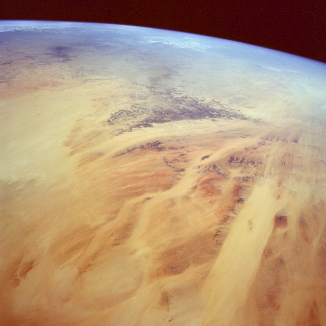 |
| STS052-082-007 Sandy Desert, Eastern Chad October 1992 The scene displayed in this high-oblique, southeast-looking photograph, which points toward the Ennedi Plateau (darker structure toward the horizon) of eastern Chad, is part of the great Sahara Desert. This photograph shows vast quantities of sand and several major corridors where sand continually moves across a landscape that has little or no vegetation. The only impediments to the sand, which is moved by the prevailing northeasterly winds, are the darker, fragmented remnants of resistant sandstone rock outcrops. The reds, yellows, and oranges identify the various sand colors in the region. The somewhat linear, uniform bands are depressions where massive deposits of sand have accumulated. It is through these "sand valleys" that much of the blowing sand is channeled during sandstorms. This photograph helps explain why this hostile environment does not promote the establishment of permanent human settlements. |
| Images: | All Available Images Low-Resolution 87k |
|
| Mission: | STS052 |
|
| Roll - Frame: | 82 - 7 |
|
| Geographical Name: | NIGER |
|
| Features: | GRAND ERG OF BILMA |
|
| Center Lat x Lon: | 19.0N x 15.0E |
|
| Film Exposure: | N | N=Normal exposure, U=Under exposed, O=Over exposed, F=out of Focus |
| Percentage of Cloud Cover-CLDP: | 0 |
|
| Camera:: | HB |
|
| Camera Tilt: | HO | LO=Low Oblique, HO=High Oblique, NV=Near Vertical |
| Camera Focal Length: | 50 |
|
| Nadir to Photo Center Direction: | W | The direction from the nadir to the center point, N=North, S=South, E=East, W=West |
| Stereo?: | N | Y=Yes there is an adjacent picture of the same area, N=No there isn't |
| Orbit Number: | 45 |
|
| Date: | 19921025 | YYYYMMDD |
| Time: | 113350 | GMT HHMMSS |
| Nadir Lat: | 22.0N |
Latitude of suborbital point of spacecraft |
| Nadir Lon: | 24.5E |
Longitude of suborbital point of spacecraft |
| Sun Azimuth: | 214 | Clockwise angle in degrees from north to the sun measured at the nadir point |
| Space Craft Altitude: | 157 | nautical miles |
| Sun Elevation: | 50 | Angle in degrees between the horizon and the sun, measured at the nadir point |
| Land Views: | DESERT, BASIN, DUNE, PLATEAU |
|
| Water Views: | |
|
| Atmosphere Views: | |
|
| Man Made Views: | |
|
| City Views: | |
|
Photo is not associated with any sequences | ||
| NASA Home Page |
JSC Home Page |
JSC Digital Image Collection |
Earth Science & Remote Sensing |
|
This service is provided by the International Space Station program and the JSC Earth Science & Remote Sensing Unit, ARES Division, Exploration Integration Science Directorate.

|