Geographic Region: NIGERIA
Feature: LAKE CHAD
|
Geographic Region: NIGERIA Feature: LAKE CHAD |
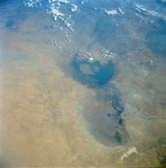 |
| STS052-080-066 Lake Chad, Africa November 1992 With standing water visible only in its southern basin, Lake Chad can be seen in this south-southeast-looking, low-oblique view. A major drought, which has been under way since 1970 with few interruptions, has plagued this and other regions of northern Africa. The northern basin, which is very vulnerable to any fluctuations in the climate, has dried and shrunk, displaying many sand dunes. The darker areas visible within the northern basin are marshland and swampland with dense scrub-type vegetation. The flow of the Komadugu Gana River into the northern basin of the lake from the west has also been reduced by the prolonged drought. In the southern basin of the lake, and especially in the eastern part of the lake, many sand dunes or islets can be seen scattered throughout. The flow of water into the southern basin from the Chari River has also been reduced by the prolonged drought. The average depth of the southern basin has been reduced to less than 15 feet (4.5 meters) compared to its average depth in 1968 of 20 feet (6 meters). To the east of Lake Chad, the sand of the Manga Desert is visible. Due to the prevailing wind, the sand is moving westward. Encroaching sand can already be seen as light-colored material moving into the eastern portions of the northern basin. (See AS7-008-1932 for a photograph that shows the condition of Lake Chad before the prolonged drought began in 1970.) |
| Images: | All Available Images Low-Resolution 103k |
|
| Mission: | STS052 |
|
| Roll - Frame: | 80 - 66 |
|
| Geographical Name: | NIGERIA |
|
| Features: | LAKE CHAD |
|
| Center Lat x Lon: | 13.0N x 14.0E |
|
| Film Exposure: | N | N=Normal exposure, U=Under exposed, O=Over exposed, F=out of Focus |
| Percentage of Cloud Cover-CLDP: | 0 |
|
| Camera:: | HB |
|
| Camera Tilt: | LO | LO=Low Oblique, HO=High Oblique, NV=Near Vertical |
| Camera Focal Length: | 100 |
|
| Nadir to Photo Center Direction: | The direction from the nadir to the center point, N=North, S=South, E=East, W=West |
|
| Stereo?: | Y | Y=Yes there is an adjacent picture of the same area, N=No there isn't |
| Orbit Number: | |
|
| Date: | 199210__ | YYYYMMDD |
| Time: | GMT HHMMSS |
|
| Nadir Lat: | N |
Latitude of suborbital point of spacecraft |
| Nadir Lon: | E |
Longitude of suborbital point of spacecraft |
| Sun Azimuth: | Clockwise angle in degrees from north to the sun measured at the nadir point |
|
| Space Craft Altitude: | nautical miles |
|
| Sun Elevation: | Angle in degrees between the horizon and the sun, measured at the nadir point |
|
| Land Views: | DUNE, DESERT |
|
| Water Views: | LAKE |
|
| Atmosphere Views: | SMOKE |
|
| Man Made Views: | |
|
| City Views: | |
|
Associated Photos in Sequence:  Photo #: AS07-8-1932 Photo #: AS07-8-1932Description: AFRICA, LAKE CHAD-1968--LAKE LEVELS BEFORE BEGINNING OF DROUGHT, 1970 Sequence ID: 3A  Photo #: STS052-99-9 Photo #: STS052-99-9Description: AFRICA, LAKE CHAD-1992--LAKE LEVELS FROM DROUGHT THAT BEGAN IN 1970 Sequence ID: 3B  Photo #: STS052-80-66 ** Currently displayed photo ** Photo #: STS052-80-66 ** Currently displayed photo ** Description: AFRICA, LAKE CHAD-1992--LAKE LEVELS FROM DROUGHT THAT BEGAN IN 1970 Sequence ID: 3C  Photo #: STS061-75-22 Photo #: STS061-75-22Description: AFRICA, LAKE CHAD-1993--LAKE LEVELS FROM DROUGHT THAT BEGAN IN 1970 Sequence ID: 3D  Photo #: STS061-75-23 Photo #: STS061-75-23Description: AFRICA, LAKE CHAD-1993--LAKE LEVELS FROM DROUGHT THAT BEGAN IN 1970 Sequence ID: 3E | ||
| NASA Home Page |
JSC Home Page |
JSC Digital Image Collection |
Earth Science & Remote Sensing |
|
This service is provided by the International Space Station program and the JSC Earth Science & Remote Sensing Unit, ARES Division, Exploration Integration Science Directorate.

|