Geographic Region: LIBYA
Feature: UAU ENNAMUS VOLCANO
|
Geographic Region: LIBYA Feature: UAU ENNAMUS VOLCANO |
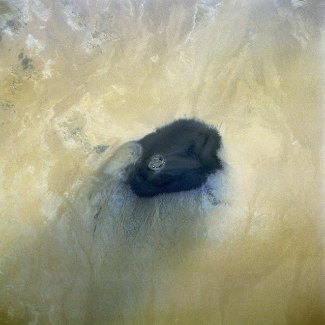 |
| STS052-075-017 Uau En Namus Volcano, Southern Libya October 1992 Surrounded by the Sahara Desert in south-central Libya, the Uau en Namus Volcano stands like a lone igneous sentinel in an otherwise sandy environment. The volcano, approximately 45 miles (70 kilometers) south of the large Djebel Haroudj basaltic region, has been described as one of the most beautiful scenes in Libya. In addition to the uniqueness of its solitary location, the volcano's caldera rim rises approximately only 200 feet (61 meters) above the surrounding terrain. The alignments of both the black ash encircling the caldera and the sand streamers indicate the prevailing wind is from the northeast. Within the caldera are three separate lakes surrounded by tall weeds and groups of wild date palms. Despite the presence of potable water, date palms, and other vegetation, no permanent settlement exists. Mosquitoes are the reason for the lack of a permanent settlement. The Arabic word "namus" means mosquitoes; thus, the Americanized name for this volcano is Volcano of Mosquitoes. |
| Images: | All Available Images Low-Resolution 114k |
|
| Mission: | STS052 |
|
| Roll - Frame: | 75 - 17 |
|
| Geographical Name: | LIBYA |
|
| Features: | UAU ENNAMUS VOLCANO |
|
| Center Lat x Lon: | 25.0N x 18.0E |
|
| Film Exposure: | N | N=Normal exposure, U=Under exposed, O=Over exposed, F=out of Focus |
| Percentage of Cloud Cover-CLDP: | 0 |
|
| Camera:: | HB |
|
| Camera Tilt: | 21 | LO=Low Oblique, HO=High Oblique, NV=Near Vertical |
| Camera Focal Length: | 250 |
|
| Nadir to Photo Center Direction: | N | The direction from the nadir to the center point, N=North, S=South, E=East, W=West |
| Stereo?: | N | Y=Yes there is an adjacent picture of the same area, N=No there isn't |
| Orbit Number: | 45 |
|
| Date: | 19921025 | YYYYMMDD |
| Time: | 113208 | GMT HHMMSS |
| Nadir Lat: | 24.0N |
Latitude of suborbital point of spacecraft |
| Nadir Lon: | 17.9E |
Longitude of suborbital point of spacecraft |
| Sun Azimuth: | 203 | Clockwise angle in degrees from north to the sun measured at the nadir point |
| Space Craft Altitude: | 158 | nautical miles |
| Sun Elevation: | 51 | Angle in degrees between the horizon and the sun, measured at the nadir point |
| Land Views: | DESERT, VOLCANO, PLAIN |
|
| Water Views: | LAKE |
|
| Atmosphere Views: | |
|
| Man Made Views: | |
|
| City Views: | |
|
Photo is not associated with any sequences | ||
| NASA Home Page |
JSC Home Page |
JSC Digital Image Collection |
Earth Science & Remote Sensing |
|
This service is provided by the International Space Station program and the JSC Earth Science & Remote Sensing Unit, ARES Division, Exploration Integration Science Directorate.

|