Geographic Region: INDIA
Feature: W COAST, PUNE
|
Geographic Region: INDIA Feature: W COAST, PUNE |
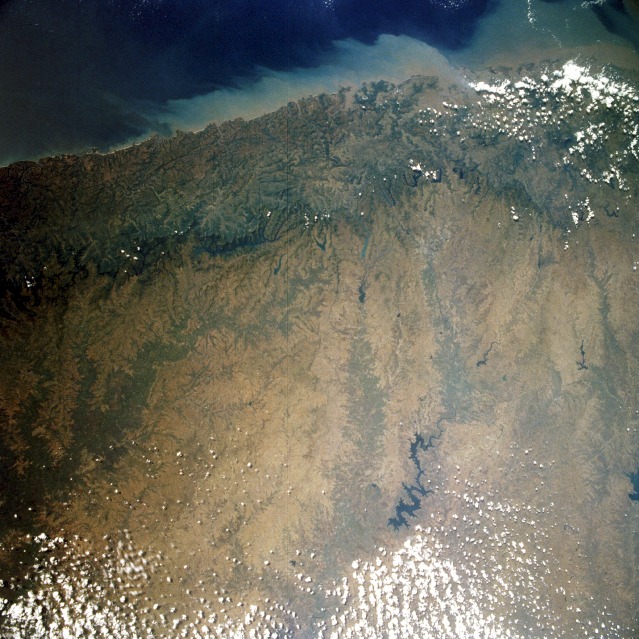 |
| STS052-072-043 Western Ghats, India October 1992 The rugged, forest-covered Western Ghats, an almost uninterrupted chain that parallels the west Indian coast of the Arabian Sea for 1000 miles (1600 kilometers), can be seen in this west-southwest-looking photograph. The mountains present a formidable barrier to winds and transportation; few highways and railroads traverse the chain. With elevations of 3000 to 5000 feet (900 to 1500 meters) above the narrow coastal plain, the mountains have steep seaward faces, while their landward sides that connect with Deccan Plateau (east side of the photograph) are gentle and rolling. Annual precipitation of 70 inches (178 centimeters) along the coast decreases inland to less than 30 inches (76 centimeters). The streams of the Western Ghats are used for hydroelectric power generation. Partially obscured by clouds (northwest corner of the photograph) is the city of Bombay. |
| Images: | All Available Images Low-Resolution 154k |
|
| Mission: | STS052 |
|
| Roll - Frame: | 72 - 43 |
|
| Geographical Name: | INDIA |
|
| Features: | W COAST, PUNE |
|
| Center Lat x Lon: | 18.0N x 74.5E |
|
| Film Exposure: | N | N=Normal exposure, U=Under exposed, O=Over exposed, F=out of Focus |
| Percentage of Cloud Cover-CLDP: | 10 |
|
| Camera:: | HB |
|
| Camera Tilt: | 21 | LO=Low Oblique, HO=High Oblique, NV=Near Vertical |
| Camera Focal Length: | 50 |
|
| Nadir to Photo Center Direction: | N | The direction from the nadir to the center point, N=North, S=South, E=East, W=West |
| Stereo?: | N | Y=Yes there is an adjacent picture of the same area, N=No there isn't |
| Orbit Number: | 59 |
|
| Date: | 19921026 | YYYYMMDD |
| Time: | 083904 | GMT HHMMSS |
| Nadir Lat: | 17.0N |
Latitude of suborbital point of spacecraft |
| Nadir Lon: | 74.4E |
Longitude of suborbital point of spacecraft |
| Sun Azimuth: | 225 | Clockwise angle in degrees from north to the sun measured at the nadir point |
| Space Craft Altitude: | 157 | nautical miles |
| Sun Elevation: | 49 | Angle in degrees between the horizon and the sun, measured at the nadir point |
| Land Views: | MOUNTAIN, COAST, FOREST, PLATEAU |
|
| Water Views: | OCEAN, SEDIMENT, RESERVOIR, RIVER |
|
| Atmosphere Views: | |
|
| Man Made Views: | DEFORESTATION |
|
| City Views: | |
|
Photo is not associated with any sequences | ||
| NASA Home Page |
JSC Home Page |
JSC Digital Image Collection |
Earth Science & Remote Sensing |
|
This service is provided by the International Space Station program and the JSC Earth Science & Remote Sensing Unit, ARES Division, Exploration Integration Science Directorate.

|