
Geographic Region: USA-FLORIDA
Feature: COAST, FT. MYERS, EVERGLADES
|
Geographic Region: USA-FLORIDA Feature: COAST, FT. MYERS, EVERGLADES |
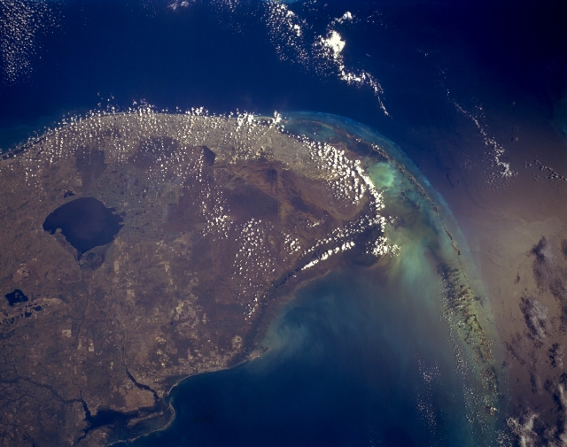 |
| STS052-153-067 South Florida, U.S.A. October 1992 This synoptic, southeast-looking photograph portrays several manmade and natural features--Charlotte Bay (lower left); large, dark Lake Okeechobee, south and southwest of which are large sugarcane fields; the densely populated Miami Gold Coast; shallow Florida Bay; and the southwest-arcing Florida Keys. Extending from the sugarcane fields south of Lake Okeechobee to the southern tip of mainland Florida are The Everglades, an area of extensive swamp, saw grass, and hardwood hammocks. Known as a great "river of grass," The Everglades are an environmentally sensitive region with a delicate balance of water resource usage; many dams and canals constructed south of Lake Okeechobee have altered the natural water flow to the south and southwest. |
| Images: | All Available Images Low-Resolution 242k |
|
| Mission: | STS052 |
|
| Roll - Frame: | 153 - 67 |
|
| Geographical Name: | USA-FLORIDA |
|
| Features: | COAST, FT. MYERS, EVERGLADES |
|
| Center Lat x Lon: | 26.0N x 80.5W |
|
| Film Exposure: | N | N=Normal exposure, U=Under exposed, O=Over exposed, F=out of Focus |
| Percentage of Cloud Cover-CLDP: | 30 |
|
| Camera:: | LH |
|
| Camera Tilt: | 14 | LO=Low Oblique, HO=High Oblique, NV=Near Vertical |
| Camera Focal Length: | 90 |
|
| Nadir to Photo Center Direction: | NE | The direction from the nadir to the center point, N=North, S=South, E=East, W=West |
| Stereo?: | Y | Y=Yes there is an adjacent picture of the same area, N=No there isn't |
| Orbit Number: | 49 |
|
| Date: | 19921025 | YYYYMMDD |
| Time: | 173059 | GMT HHMMSS |
| Nadir Lat: | 25.7N |
Latitude of suborbital point of spacecraft |
| Nadir Lon: | 81.1W |
Longitude of suborbital point of spacecraft |
| Sun Azimuth: | 189 | Clockwise angle in degrees from north to the sun measured at the nadir point |
| Space Craft Altitude: | 158 | nautical miles |
| Sun Elevation: | 52 | Angle in degrees between the horizon and the sun, measured at the nadir point |
| Land Views: | |
|
| Water Views: | LAKE, BAY, GULF, REEF |
|
| Atmosphere Views: | |
|
| Man Made Views: | AGRICULTURE |
|
| City Views: | |
|
Photo is not associated with any sequences | ||
| NASA Home Page |
JSC Home Page |
JSC Digital Image Collection |
Earth Science & Remote Sensing |
|
This service is provided by the International Space Station program and the JSC Earth Science & Remote Sensing Unit, ARES Division, Exploration Integration Science Directorate.

|