
Geographic Region: USA-TEXAS
Feature: COAST,CORPUS CHRISTI AREA
|
Geographic Region: USA-TEXAS Feature: COAST,CORPUS CHRISTI AREA |
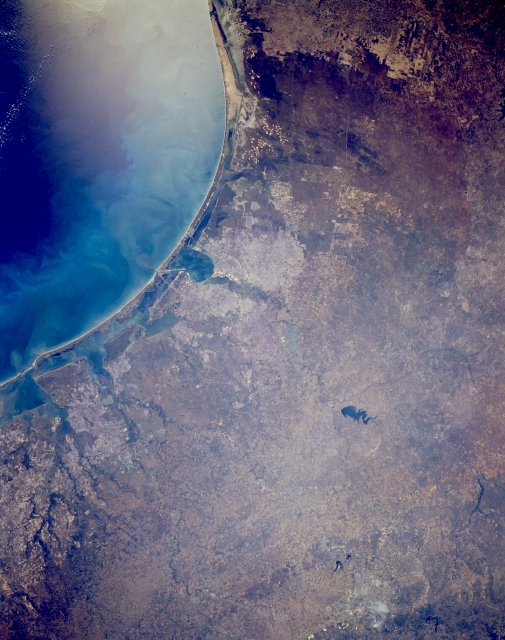 |
| STS052-153-56 Corpus Christi, South Padre Island to San Antonio, Cotulla to Lavaca Bay, Texas, U.S.A. October 1992 Apparent in this panoramic photograph is the south Texas coastal plain extending from the southern edge of Matagorda Bay to oval Corpus Christi Bay (center of photograph) and south to Padre Island. Along this section of the Texas coast, sand barrier islands parallel the coast and create a series of bays. Much of the landscape south of Corpus Christi Bay consists of flat, windswept sandy areas and occasional elevated sand dunes, which are stabilized by vegetation. Much of the land is used for livestock grazing and cotton production. Discernible are dark Choke Canyon Lake, a part of the Nueces River watershed, and the sediment and turbidity of the adjacent Gulf of Mexico. |
| Images: | All Available Images Low-Resolution 289k |
|
| Mission: | STS052 |
|
| Roll - Frame: | 153 - 56 |
|
| Geographical Name: | USA-TEXAS |
|
| Features: | COAST,CORPUS CHRISTI AREA |
|
| Center Lat x Lon: | 28.5N x 97.5W |
|
| Film Exposure: | N | N=Normal exposure, U=Under exposed, O=Over exposed, F=out of Focus |
| Percentage of Cloud Cover-CLDP: | 0 |
|
| Camera:: | LH |
|
| Camera Tilt: | 6 | LO=Low Oblique, HO=High Oblique, NV=Near Vertical |
| Camera Focal Length: | 90 |
|
| Nadir to Photo Center Direction: | N | The direction from the nadir to the center point, N=North, S=South, E=East, W=West |
| Stereo?: | Y | Y=Yes there is an adjacent picture of the same area, N=No there isn't |
| Orbit Number: | 49 |
|
| Date: | 19921025 | YYYYMMDD |
| Time: | 172703 | GMT HHMMSS |
| Nadir Lat: | 28.2N |
Latitude of suborbital point of spacecraft |
| Nadir Lon: | 97.5W |
Longitude of suborbital point of spacecraft |
| Sun Azimuth: | 163 | Clockwise angle in degrees from north to the sun measured at the nadir point |
| Space Craft Altitude: | 158 | nautical miles |
| Sun Elevation: | 48 | Angle in degrees between the horizon and the sun, measured at the nadir point |
| Land Views: | COAST, PLAIN |
|
| Water Views: | GULF, BAY, LAKE |
|
| Atmosphere Views: | |
|
| Man Made Views: | HIGHWAY |
|
| City Views: | |
|
Photo is not associated with any sequences | ||
| NASA Home Page |
JSC Home Page |
JSC Digital Image Collection |
Earth Science & Remote Sensing |
|
This service is provided by the International Space Station program and the JSC Earth Science & Remote Sensing Unit, ARES Division, Exploration Integration Science Directorate.

|