
Geographic Region: ALGERIA
Feature: TANEZROUFT AREA
|
Geographic Region: ALGERIA Feature: TANEZROUFT AREA |
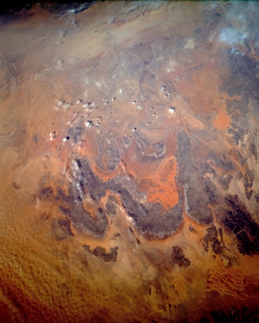 |
| STS052-151-227 Tanezrouft, Algeria October 1992 The Tanezrouft region in south-central Algeria is known as the "Land of Thirst" and the "Land of Terror." The Tanezrouft region, a western extension of the more massive Ahaggar Mountains to the east, is comprised of sandstone formations, whereas the Ahaggar Mountains are metamorphic in origin. The physiography of the region is dark sandstone hills with many steep canyon walls rising 800 to 1600 feet (250 to 500 meters) above the surrounding arid terrain; sandy areas with dune fields; and numerous sandstone outcrop patterns of concentric loops and ellipses. The reddish color of some of the sand results from metal oxides being dissolved from the parent rocks. Rainfall amounts in the Tanezrouft area rarely exceed 3 inches (8 centimeters) annually. In an earlier geologic period the region experienced substantial water erosion; now the landscape is being modified by wind erosion. Since there is very little vegetation in the area, wind erosion is a serious environmental degradation process. |
| Images: | All Available Images Low-Resolution 97k |
|
| Mission: | STS052 |
|
| Roll - Frame: | 151 - 227 |
|
| Geographical Name: | ALGERIA |
|
| Features: | TANEZROUFT AREA |
|
| Center Lat x Lon: | N x E |
|
| Film Exposure: | U | N=Normal exposure, U=Under exposed, O=Over exposed, F=out of Focus |
| Percentage of Cloud Cover-CLDP: | 5 |
|
| Camera:: | LH |
|
| Camera Tilt: | LO | LO=Low Oblique, HO=High Oblique, NV=Near Vertical |
| Camera Focal Length: | 90 |
|
| Nadir to Photo Center Direction: | The direction from the nadir to the center point, N=North, S=South, E=East, W=West |
|
| Stereo?: | N | Y=Yes there is an adjacent picture of the same area, N=No there isn't |
| Orbit Number: | 30 |
|
| Date: | 19921024 | YYYYMMDD |
| Time: | 125952 | GMT HHMMSS |
| Nadir Lat: | 24.5N |
Latitude of suborbital point of spacecraft |
| Nadir Lon: | 1.9E |
Longitude of suborbital point of spacecraft |
| Sun Azimuth: | 212 | Clockwise angle in degrees from north to the sun measured at the nadir point |
| Space Craft Altitude: | 157 | nautical miles |
| Sun Elevation: | 48 | Angle in degrees between the horizon and the sun, measured at the nadir point |
| Land Views: | MOUNTAIN, DESERT, DUNE, PLATEAU |
|
| Water Views: | |
|
| Atmosphere Views: | |
|
| Man Made Views: | |
|
| City Views: | |
|
Photo is not associated with any sequences | ||
| NASA Home Page |
JSC Home Page |
JSC Digital Image Collection |
Earth Science & Remote Sensing |
|
This service is provided by the International Space Station program and the JSC Earth Science & Remote Sensing Unit, ARES Division, Exploration Integration Science Directorate.

|