Geographic Region: ALGERIA
Feature: TINRHERT PLAT,DUNES,MTS.
|
Geographic Region: ALGERIA Feature: TINRHERT PLAT,DUNES,MTS. |
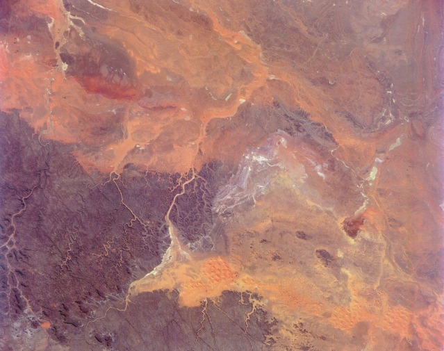 |
| STS052-151-159 Tassili N' Ajjer, Algeria October 1992 The northeastern extension of the Tassili N' Ajjer is an austere, beautiful desert. From the dark, heavily eroded sandstone plateau in the southwestern quadrant of the photograph to the numerous drainage valleys filled with scattered sand sheets and sand dunes, the vivid desert colors range from dull red to black. The wide variety of colors results from desert varnish, which is a thin layer of metallic oxides dissolved from the rocks and deposited on the surface as a stain. This area in southeast Algeria is strategic because it is on the Algeria-Libya border. The border is visible near the center of the photograph in the gray area where very narrow lines could be a roadway, a fence line, or a combination of the two. |
| Images: | All Available Images Low-Resolution 103k |
|
| Mission: | STS052 |
|
| Roll - Frame: | 151 - 159 |
|
| Geographical Name: | ALGERIA |
|
| Features: | TINRHERT PLAT,DUNES,MTS. |
|
| Center Lat x Lon: | 26.5N x 8.5E |
|
| Film Exposure: | N | N=Normal exposure, U=Under exposed, O=Over exposed, F=out of Focus |
| Percentage of Cloud Cover-CLDP: | 0 |
|
| Camera:: | LH |
|
| Camera Tilt: | 33 | LO=Low Oblique, HO=High Oblique, NV=Near Vertical |
| Camera Focal Length: | 250 |
|
| Nadir to Photo Center Direction: | SW | The direction from the nadir to the center point, N=North, S=South, E=East, W=West |
| Stereo?: | Y | Y=Yes there is an adjacent picture of the same area, N=No there isn't |
| Orbit Number: | 29 |
|
| Date: | 19921024 | YYYYMMDD |
| Time: | 112604 | GMT HHMMSS |
| Nadir Lat: | 27.5N |
Latitude of suborbital point of spacecraft |
| Nadir Lon: | 9.9E |
Longitude of suborbital point of spacecraft |
| Sun Azimuth: | 188 | Clockwise angle in degrees from north to the sun measured at the nadir point |
| Space Craft Altitude: | 158 | nautical miles |
| Sun Elevation: | 50 | Angle in degrees between the horizon and the sun, measured at the nadir point |
| Land Views: | DESERT, DUNE, MOUNTAIN, PLATEAU |
|
| Water Views: | RIVER, PLAYA |
|
| Atmosphere Views: | |
|
| Man Made Views: | |
|
| City Views: | |
|
Photo is not associated with any sequences | ||
| NASA Home Page |
JSC Home Page |
JSC Digital Image Collection |
Earth Science & Remote Sensing |
|
This service is provided by the International Space Station program and the JSC Earth Science & Remote Sensing Unit, ARES Division, Exploration Integration Science Directorate.

|