Geographic Region: MALI
Feature: NIGER RIVER
|
Geographic Region: MALI Feature: NIGER RIVER |
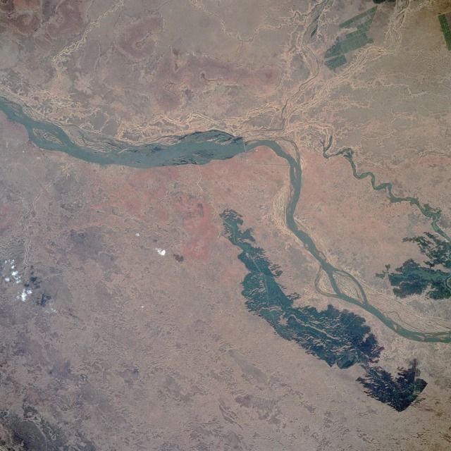 |
| STS052-100-034 Niger River, Mali October 1992 The semiarid, steppe grasslands of central Mali shown in this photograph lie on the southwestern fringe of the inland delta of the Niger River. The small city of Markala is located southeast of the single bridge that spans the northeasterly-flowing Niger. Most of the narrow linear features, which are visible on both the north and south sides of the main river channel, are irrigation ditches. Large dark areas south of the river are irrigated agricultural fields. Large irrigated field patterns are also visible north of the Niger River along the Fala River. This part of Mali is in the center of the Sahel, a transition zone where overgrazing is changing the appearance of the landscape. The area is an environmentally sensitive region where, because of fluctuations and decreasing amounts of rainfall, the grasslands can quickly become a true desert with virtually no vegetation--a process known as desertification. The annual range of precipitation fluctuates between 12 and 20 inches (30 and 50 centimeters). |
| Images: | All Available Images Low-Resolution 133k |
|
| Mission: | STS052 |
|
| Roll - Frame: | 100 - 34 |
|
| Geographical Name: | MALI |
|
| Features: | NIGER RIVER |
|
| Center Lat x Lon: | 14.0N x 6W |
|
| Film Exposure: | N | N=Normal exposure, U=Under exposed, O=Over exposed, F=out of Focus |
| Percentage of Cloud Cover-CLDP: | 0 |
|
| Camera:: | HB |
|
| Camera Tilt: | 18 | LO=Low Oblique, HO=High Oblique, NV=Near Vertical |
| Camera Focal Length: | 250 |
|
| Nadir to Photo Center Direction: | NW | The direction from the nadir to the center point, N=North, S=South, E=East, W=West |
| Stereo?: | N | Y=Yes there is an adjacent picture of the same area, N=No there isn't |
| Orbit Number: | 94 |
|
| Date: | 19921028 | YYYYMMDD |
| Time: | 131527 | GMT HHMMSS |
| Nadir Lat: | 13.5N |
Latitude of suborbital point of spacecraft |
| Nadir Lon: | 5.3W |
Longitude of suborbital point of spacecraft |
| Sun Azimuth: | 214 | Clockwise angle in degrees from north to the sun measured at the nadir point |
| Space Craft Altitude: | 157 | nautical miles |
| Sun Elevation: | 58 | Angle in degrees between the horizon and the sun, measured at the nadir point |
| Land Views: | VALLEY, HILL, PLAIN |
|
| Water Views: | RIVER, SWAMP |
|
| Atmosphere Views: | |
|
| Man Made Views: | AGRICULTURE |
|
| City Views: | |
|
Photo is not associated with any sequences | ||
| NASA Home Page |
JSC Home Page |
JSC Digital Image Collection |
Earth Science & Remote Sensing |
|
This service is provided by the International Space Station program and the JSC Earth Science & Remote Sensing Unit, ARES Division, Exploration Integration Science Directorate.

|