
Geographic Region: AUSTRALIA-Q
Feature: CURTIS ISLAND, SEDIMENT
|
Geographic Region: AUSTRALIA-Q Feature: CURTIS ISLAND, SEDIMENT |
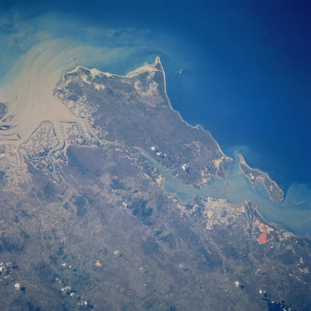 |
| STS051-078-064 Curtis Island, Queensland, Australia September 1993 Curtis island, the large island off the northeast coast of Queensland, is located north of the city of Gladstone. While none of the detailed infrastructure of the city is discernible, the location of this rapidly developing urban area can be identified as the lighter colored area west of the smaller island (Facing Island) and north of the orange-looking feature near the right bottom corner of the picture. The orange looking feature is possibly associated with the world's largest aluminum processing facility with a settling pond or area of waste residue. The large aluminum processing industry, coupled with a natural deep-water port, has helped this region become one of Australia's leading industrial sites. A large sediment plume is clearly visible in Keppel Bay along the northwest coast of Curtis Island, as it flows from the tidal flats and delta of the Fitzroy River and curves around towards the Capricorn Channel. Compare the overall green vegetation of this spring-time photograph with the brown color of the STS055-151-146 image (a late fall view of the same region). Notice also that relative size of the sediment plume at the northwest end of Curtis Island in Keppel Bay is markedly smaller in size. |
| Images: | All Available Images Low-Resolution 304k |
|
| Mission: | STS051 |
|
| Roll - Frame: | 78 - 64 |
|
| Geographical Name: | AUSTRALIA-Q |
|
| Features: | CURTIS ISLAND, SEDIMENT |
|
| Center Lat x Lon: | 23.5S x 151.0E |
|
| Film Exposure: | N | N=Normal exposure, U=Under exposed, O=Over exposed, F=out of Focus |
| Percentage of Cloud Cover-CLDP: | 0 |
|
| Camera:: | HB |
|
| Camera Tilt: | LO | LO=Low Oblique, HO=High Oblique, NV=Near Vertical |
| Camera Focal Length: | 250 |
|
| Nadir to Photo Center Direction: | The direction from the nadir to the center point, N=North, S=South, E=East, W=West |
|
| Stereo?: | Y | Y=Yes there is an adjacent picture of the same area, N=No there isn't |
| Orbit Number: | |
|
| Date: | 199309__ | YYYYMMDD |
| Time: | GMT HHMMSS |
|
| Nadir Lat: | N |
Latitude of suborbital point of spacecraft |
| Nadir Lon: | E |
Longitude of suborbital point of spacecraft |
| Sun Azimuth: | Clockwise angle in degrees from north to the sun measured at the nadir point |
|
| Space Craft Altitude: | nautical miles |
|
| Sun Elevation: | Angle in degrees between the horizon and the sun, measured at the nadir point |
|
| Land Views: | ISLAND, COAST |
|
| Water Views: | RIVER, SEDIMENT, BAY |
|
| Atmosphere Views: | |
|
| Man Made Views: | |
|
| City Views: | |
|
Photo is not associated with any sequences | ||
| NASA Home Page |
JSC Home Page |
JSC Digital Image Collection |
Earth Science & Remote Sensing |
|
This service is provided by the International Space Station program and the JSC Earth Science & Remote Sensing Unit, ARES Division, Exploration Integration Science Directorate.

|