
Geographic Region: AUSTRALIA-Q
Feature: CITY OF MOUNT ISA, LAKES
|
Geographic Region: AUSTRALIA-Q Feature: CITY OF MOUNT ISA, LAKES |
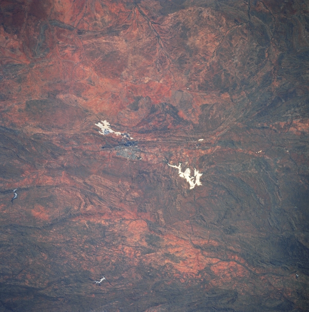 |
| STS051-078-029 Mount Isa Area, Queensland, Australia September 1993 The two highly reflective features (irregular-shaped, white in color) are sizeable water reservoirs that are located near Mount Isa in west central Queensland. The larger feature (left of center), Lake Moondarra, is one of the main sources for water for Mount Isa which is located 10 miles (16 kilometers) south of the lake. A smaller water reservoir (another irregular shaped, white feature) is visible southwest of Mount Isa. These two bodies of water stand out in marked contrast with the surrounding arid environment because of the sun's reflection off of the water's surface, a phenomena known as sun glitter or sunglint. The rugged mountainous and hilly terrain can be identified as the slightly darker landscape. Mining of silver and lead are the major minerals extracted from the mountains and some copper and zinc are also mined. The drainage feature northeast of Lake Moondarra is the headwater region of the Leichhardt River which eventually empties into the Gulf of Carpentaria; while the drainage system towards the bottom of the picture are tributaries of the Flinders River drainage basin. It is a little known fact that the city of Mount Isa has the largest area of any city in the world--covering an area larger than Switzerland (15400 square miles--40000 square kilometers). |
| Images: | All Available Images Low-Resolution 345k |
|
| Mission: | STS051 |
|
| Roll - Frame: | 78 - 29 |
|
| Geographical Name: | AUSTRALIA-Q |
|
| Features: | CITY OF MOUNT ISA, LAKES |
|
| Center Lat x Lon: | 20.5S x 139.5E |
|
| Film Exposure: | N | N=Normal exposure, U=Under exposed, O=Over exposed, F=out of Focus |
| Percentage of Cloud Cover-CLDP: | 0 |
|
| Camera:: | HB |
|
| Camera Tilt: | 24 | LO=Low Oblique, HO=High Oblique, NV=Near Vertical |
| Camera Focal Length: | 250 |
|
| Nadir to Photo Center Direction: | NW | The direction from the nadir to the center point, N=North, S=South, E=East, W=West |
| Stereo?: | Y | Y=Yes there is an adjacent picture of the same area, N=No there isn't |
| Orbit Number: | 75 |
|
| Date: | 19930917 | YYYYMMDD |
| Time: | 033809 | GMT HHMMSS |
| Nadir Lat: | 21.5S |
Latitude of suborbital point of spacecraft |
| Nadir Lon: | 140.2E |
Longitude of suborbital point of spacecraft |
| Sun Azimuth: | 324 | Clockwise angle in degrees from north to the sun measured at the nadir point |
| Space Craft Altitude: | 164 | nautical miles |
| Sun Elevation: | 62 | Angle in degrees between the horizon and the sun, measured at the nadir point |
| Land Views: | MOUNTAIN |
|
| Water Views: | LAKE, RIVER |
|
| Atmosphere Views: | |
|
| Man Made Views: | |
|
| City Views: | |
|
Photo is not associated with any sequences | ||
| NASA Home Page |
JSC Home Page |
JSC Digital Image Collection |
Earth Science & Remote Sensing |
|
This service is provided by the International Space Station program and the JSC Earth Science & Remote Sensing Unit, ARES Division, Exploration Integration Science Directorate.

|