
Geographic Region: AUSTRALIA-NT
Feature: BRUNETTE DOWNS LAKES
|
Geographic Region: AUSTRALIA-NT Feature: BRUNETTE DOWNS LAKES |
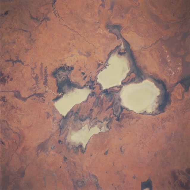 |
| STS051-078-013 Brunette Creek Area, Northern Territory, Australia September 1993 Four sizable, highly reflective surfaces are milky colored freshwater lakes that are located on the Barkly Tablelands. The surface inflow of fresh water is primarily from two different sources. A section of the Corella Creek and its swampy delta (darker landscape) is visible as the water flow enters the northeast side of Corella Lake (rectangular-shaped whitish feature--nearest top of image). The Burnette Creek channel (narrow, dark linear feature) can be traced southwesterly across the grasslands as the creek enters Lake Sylvester (roughly oval-shaped feature nearest right side of the picture). The other two milky colored features (largest and smallest in area) are also shallow lakes that have been created by the overflow from Corella Lake and Lake Sylvester. In wetter years these lakes can be connected by narrow channels. It is interesting to note that the outline of these lakes and their drainage pattern does not directly correlate to existing maps. The grasslands found in this sparsely populated environment support some pastoral grazing. |
| Images: | All Available Images Low-Resolution 91k |
|
| Mission: | STS051 |
|
| Roll - Frame: | 78 - 13 |
|
| Geographical Name: | AUSTRALIA-NT |
|
| Features: | BRUNETTE DOWNS LAKES |
|
| Center Lat x Lon: | 19S x 136.0E |
|
| Film Exposure: | N | N=Normal exposure, U=Under exposed, O=Over exposed, F=out of Focus |
| Percentage of Cloud Cover-CLDP: | 0 |
|
| Camera:: | HB |
|
| Camera Tilt: | 24 | LO=Low Oblique, HO=High Oblique, NV=Near Vertical |
| Camera Focal Length: | 250 |
|
| Nadir to Photo Center Direction: | E | The direction from the nadir to the center point, N=North, S=South, E=East, W=West |
| Stereo?: | Y | Y=Yes there is an adjacent picture of the same area, N=No there isn't |
| Orbit Number: | 75 |
|
| Date: | 19930917 | YYYYMMDD |
| Time: | 033644 | GMT HHMMSS |
| Nadir Lat: | 19.5S |
Latitude of suborbital point of spacecraft |
| Nadir Lon: | 134.9E |
Longitude of suborbital point of spacecraft |
| Sun Azimuth: | 334 | Clockwise angle in degrees from north to the sun measured at the nadir point |
| Space Craft Altitude: | 165 | nautical miles |
| Sun Elevation: | 66 | Angle in degrees between the horizon and the sun, measured at the nadir point |
| Land Views: | PLAIN |
|
| Water Views: | LAKE, RIVER |
|
| Atmosphere Views: | |
|
| Man Made Views: | |
|
| City Views: | |
|
Photo is not associated with any sequences | ||
| NASA Home Page |
JSC Home Page |
JSC Digital Image Collection |
Earth Science & Remote Sensing |
|
This service is provided by the International Space Station program and the JSC Earth Science & Remote Sensing Unit, ARES Division, Exploration Integration Science Directorate.

|