
Geographic Region: AUSTRALIA-WA
Feature: GREGORY SALT L., DESERT
|
Geographic Region: AUSTRALIA-WA Feature: GREGORY SALT L., DESERT |
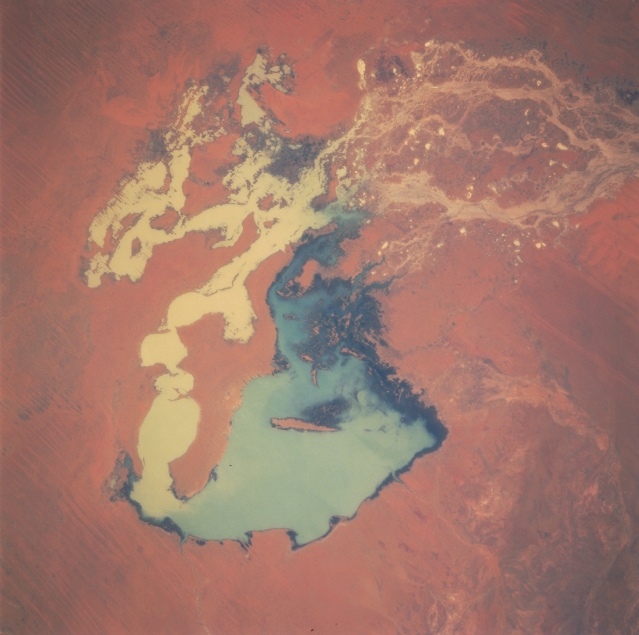 |
| STS051-076-093 Gregory Lake, Western Australia, Australia September 1993 Lake Gregory, the main body of the lake appears bluish-turquoise in the center of the picture, is a saline, inland drainage lake which has a fairly regular inflow of water. This drainage feature is located in northeastern Western Australia between the Great Sandy Desert and the Tanami Desert. The lake is considered to be a permanent lake and as such serves as a major migratory stop-over area for a variety of shorebirds. The lake also provides a major breeding habitat of several species of water birds, including cormorants and terns. The multi-braided channels (upper right) that feed water into Lake Gregory from the northeast is part of the Sturt Creek drainage system. There appears to be an excess of standing water in the channels (muddy-looking, yellowish) north and west of the main part of the lake. The surrounding landscape is one of grasslands with numerous sand ridges (thin, dark, paralleling lines on the left side of the image) visible. |
| Images: | All Available Images Low-Resolution 273k |
|
| Mission: | STS051 |
|
| Roll - Frame: | 76 - 93 |
|
| Geographical Name: | AUSTRALIA-WA |
|
| Features: | GREGORY SALT L., DESERT |
|
| Center Lat x Lon: | 20S x 127.5E |
|
| Film Exposure: | N | N=Normal exposure, U=Under exposed, O=Over exposed, F=out of Focus |
| Percentage of Cloud Cover-CLDP: | 0 |
|
| Camera:: | HB |
|
| Camera Tilt: | LO | LO=Low Oblique, HO=High Oblique, NV=Near Vertical |
| Camera Focal Length: | 250 |
|
| Nadir to Photo Center Direction: | The direction from the nadir to the center point, N=North, S=South, E=East, W=West |
|
| Stereo?: | Y | Y=Yes there is an adjacent picture of the same area, N=No there isn't |
| Orbit Number: | |
|
| Date: | 199309__ | YYYYMMDD |
| Time: | GMT HHMMSS |
|
| Nadir Lat: | N |
Latitude of suborbital point of spacecraft |
| Nadir Lon: | E |
Longitude of suborbital point of spacecraft |
| Sun Azimuth: | Clockwise angle in degrees from north to the sun measured at the nadir point |
|
| Space Craft Altitude: | nautical miles |
|
| Sun Elevation: | Angle in degrees between the horizon and the sun, measured at the nadir point |
|
| Land Views: | DESERT |
|
| Water Views: | LAKE, SEDIMENT, RIVER |
|
| Atmosphere Views: | |
|
| Man Made Views: | |
|
| City Views: | |
|
Photo is not associated with any sequences | ||
| NASA Home Page |
JSC Home Page |
JSC Digital Image Collection |
Earth Science & Remote Sensing |
|
This service is provided by the International Space Station program and the JSC Earth Science & Remote Sensing Unit, ARES Division, Exploration Integration Science Directorate.

|