Geographic Region: BRAZIL
Feature: SABRADINHO RES., SMOKE
|
Geographic Region: BRAZIL Feature: SABRADINHO RES., SMOKE |
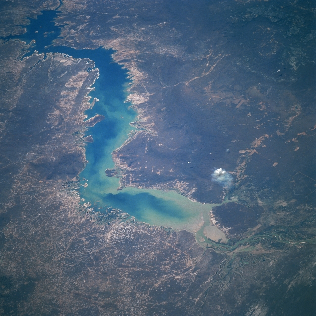 |
| STS051-076-028 Sobradinho Reservoir, Bahia, Brazil September 1993 The entire length of the Sobradinho Reservoir, the largest reservoir in Brazil (1629 square miles- 4220 square kilometers), is visible in this east-looking view. Located in the state of Bahia, the reservoir is part of the Sao Francisco River Basin. Maximum depth of the reservoir is 90 feet (30 meters) and the mean depth is about 28 feet (8.6 meters). The alignment of the reservoir is generally southwest to northeast. The dam is visible near the upper left corner of the image. As evidenced by this picture a great deal of silt (light-colored sediment pattern in the water) is flowing into and building up in the reservoir. Although the region is sparsely populated and semiarid, some livestock herding with beef cattle prevails in the better grassy zones. The vegetation surrounding the reservoir is grassland and semiarid scrub. A small smoke plume (white feature) is located along the southeast end of the reservoir. |
| Images: | All Available Images Low-Resolution 351k |
|
| Mission: | STS051 |
|
| Roll - Frame: | 76 - 28 |
|
| Geographical Name: | BRAZIL |
|
| Features: | SABRADINHO RES., SMOKE |
|
| Center Lat x Lon: | 9.5S x 42W |
|
| Film Exposure: | N | N=Normal exposure, U=Under exposed, O=Over exposed, F=out of Focus |
| Percentage of Cloud Cover-CLDP: | 0 |
|
| Camera:: | HB |
|
| Camera Tilt: | LO | LO=Low Oblique, HO=High Oblique, NV=Near Vertical |
| Camera Focal Length: | 250 |
|
| Nadir to Photo Center Direction: | The direction from the nadir to the center point, N=North, S=South, E=East, W=West |
|
| Stereo?: | Y | Y=Yes there is an adjacent picture of the same area, N=No there isn't |
| Orbit Number: | |
|
| Date: | 199309__ | YYYYMMDD |
| Time: | GMT HHMMSS |
|
| Nadir Lat: | N |
Latitude of suborbital point of spacecraft |
| Nadir Lon: | E |
Longitude of suborbital point of spacecraft |
| Sun Azimuth: | Clockwise angle in degrees from north to the sun measured at the nadir point |
|
| Space Craft Altitude: | nautical miles |
|
| Sun Elevation: | Angle in degrees between the horizon and the sun, measured at the nadir point |
|
| Land Views: | |
|
| Water Views: | RESERVOIR, SEDIMENT |
|
| Atmosphere Views: | SMOKE |
|
| Man Made Views: | |
|
| City Views: | |
|
Photo is not associated with any sequences | ||
| NASA Home Page |
JSC Home Page |
JSC Digital Image Collection |
Earth Science & Remote Sensing |
|
This service is provided by the International Space Station program and the JSC Earth Science & Remote Sensing Unit, ARES Division, Exploration Integration Science Directorate.

|