Geographic Region: USA-HAWAII
Feature: HAWAII I.,KOHAIA MTS.
|
Geographic Region: USA-HAWAII Feature: HAWAII I.,KOHAIA MTS. |
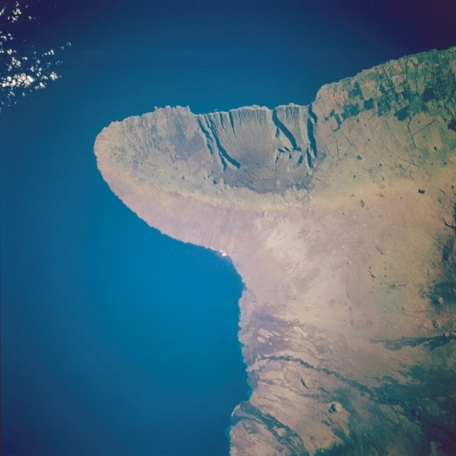 |
| STS051-102-083 Kohala Mountains, Hawaii, U.S.A. September 1993 The Kohala Mountains on the northernmost peninsula of the big island of Hawaii [their highest point reaching 5505 feet (1678 meters)] show the influence of topography on rainfall--greater rainfall on the northeast slopes have produced an abundance of vegetation, while the southwest slopes exhibit a sparsely vegetated landscape. This photograph provides a classic example of the rain shadow effect--winds from the northeast bring moisture over the mountains and through orographic uplift drop most of the moisture on the windward side of the mountains. The darker linear features on the windward side of the Kohala Mountains indicate that erosion is more severe on the northeast-facing slopes because of increased rainfall. |
| Images: | All Available Images Low-Resolution 278k |
|
| Mission: | STS051 |
|
| Roll - Frame: | 102 - 83 |
|
| Geographical Name: | USA-HAWAII |
|
| Features: | HAWAII I.,KOHAIA MTS. |
|
| Center Lat x Lon: | 20.0N x 155.5W |
|
| Film Exposure: | N | N=Normal exposure, U=Under exposed, O=Over exposed, F=out of Focus |
| Percentage of Cloud Cover-CLDP: | 5 |
|
| Camera:: | HB |
|
| Camera Tilt: | 17 | LO=Low Oblique, HO=High Oblique, NV=Near Vertical |
| Camera Focal Length: | 250 |
|
| Nadir to Photo Center Direction: | W | The direction from the nadir to the center point, N=North, S=South, E=East, W=West |
| Stereo?: | N | Y=Yes there is an adjacent picture of the same area, N=No there isn't |
| Orbit Number: | 53 |
|
| Date: | 19930915 | YYYYMMDD |
| Time: | 181145 | GMT HHMMSS |
| Nadir Lat: | 20.0N |
Latitude of suborbital point of spacecraft |
| Nadir Lon: | 154.7W |
Longitude of suborbital point of spacecraft |
| Sun Azimuth: | 98 | Clockwise angle in degrees from north to the sun measured at the nadir point |
| Space Craft Altitude: | 161 | nautical miles |
| Sun Elevation: | 29 | Angle in degrees between the horizon and the sun, measured at the nadir point |
| Land Views: | MOUNTAIN |
|
| Water Views: | |
|
| Atmosphere Views: | |
|
| Man Made Views: | |
|
| City Views: | |
|
Photo is not associated with any sequences | ||
| NASA Home Page |
JSC Home Page |
JSC Digital Image Collection |
Earth Science & Remote Sensing |
|
This service is provided by the International Space Station program and the JSC Earth Science & Remote Sensing Unit, ARES Division, Exploration Integration Science Directorate.

|