
Geographic Region: AUSTRALIA-Q
Feature: GEORGINA R.,BARKLY PLAT.
|
Geographic Region: AUSTRALIA-Q Feature: GEORGINA R.,BARKLY PLAT. |
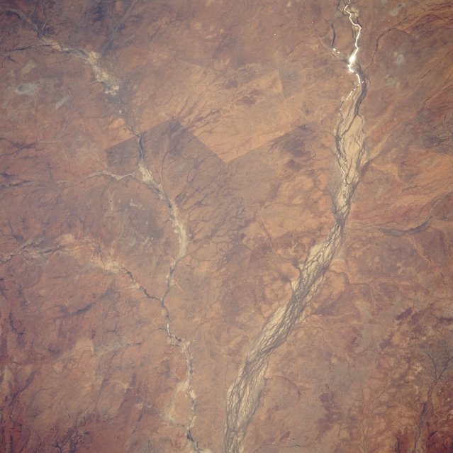 |
| STS051-101-047 Georgina River, Queensland, Australia September 1993 The Georgina River, a series of multi-braided channels nearest the right side of the image, is one of many ephemeral rivers in central Australia that drains towards the interior of the continent and then just disappears into the landscape. In this particular image the sun's reflection off some standing water (called sunglint) in the Georgina River is visible as a white-looking, curving line (upper right) just north of the Roxborough Downs area. Pituri Creek and several smaller tributaries also visible in the western half of the picture. Pituri Creek is close to the Georgina River near the town of Glenormiston (small dark spot on Pituri Creek at the bottom center of the image). The linear color change (slightly above center of the picture) between the Georgina River and Pituri Creek probably marks a fence line or property boundary. |
| Images: | All Available Images Low-Resolution 306k |
|
| Mission: | STS051 |
|
| Roll - Frame: | 101 - 47 |
|
| Geographical Name: | AUSTRALIA-Q |
|
| Features: | GEORGINA R.,BARKLY PLAT. |
|
| Center Lat x Lon: | 22.5S x 138.5E |
|
| Film Exposure: | N | N=Normal exposure, U=Under exposed, O=Over exposed, F=out of Focus |
| Percentage of Cloud Cover-CLDP: | 0 |
|
| Camera:: | HB |
|
| Camera Tilt: | 42 | LO=Low Oblique, HO=High Oblique, NV=Near Vertical |
| Camera Focal Length: | 100 |
|
| Nadir to Photo Center Direction: | W | The direction from the nadir to the center point, N=North, S=South, E=East, W=West |
| Stereo?: | Y | Y=Yes there is an adjacent picture of the same area, N=No there isn't |
| Orbit Number: | 47 |
|
| Date: | 19930915 | YYYYMMDD |
| Time: | 050650 | GMT HHMMSS |
| Nadir Lat: | 23.3S |
Latitude of suborbital point of spacecraft |
| Nadir Lon: | 140.8E |
Longitude of suborbital point of spacecraft |
| Sun Azimuth: | 300 | Clockwise angle in degrees from north to the sun measured at the nadir point |
| Space Craft Altitude: | 162 | nautical miles |
| Sun Elevation: | 44 | Angle in degrees between the horizon and the sun, measured at the nadir point |
| Land Views: | DESERT |
|
| Water Views: | RIVER |
|
| Atmosphere Views: | |
|
| Man Made Views: | |
|
| City Views: | |
|
Photo is not associated with any sequences | ||
| NASA Home Page |
JSC Home Page |
JSC Digital Image Collection |
Earth Science & Remote Sensing |
|
This service is provided by the International Space Station program and the JSC Earth Science & Remote Sensing Unit, ARES Division, Exploration Integration Science Directorate.

|