
Geographic Region: AUSTRALIA-NT
Feature: TARRABOOL L.,CREEKS
|
Geographic Region: AUSTRALIA-NT Feature: TARRABOOL L.,CREEKS |
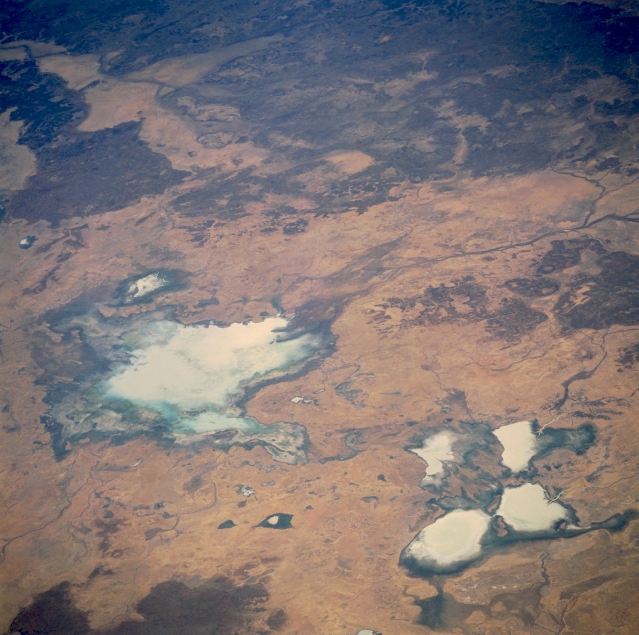 |
| STS051-101-042 Tarrabool Lake, Northern Territory, Australia September 1993 Tarrabool Lake (large, light colored feature slightly left of center) is located on the western fringe of the Barkly Tableland in northeastern Northern Territory. The actual size of the lake fluctuates as a function of the amount of precipitation that the surrounding area receives in any given year. Although the lake is fed by several creeks, it receives most of its runoff from Creswell Creek which can be seen entering the northeast end of the lake. The wooded swampland of the lake is a major breeding area for colonial water birds, especially Australian Pelicans and Straw-necked Ibis. When fully inundated, Tarrabool is the largest wooded swamp in tropical Australia. The four lighter-colored, clustered features in the lower right corner of the image includes Corella Lake and Lake Sylvester. Refer to image STS051-078-013 for a detailed description of these milky-colored lakes. |
| Images: | All Available Images Low-Resolution 328k |
|
| Mission: | STS051 |
|
| Roll - Frame: | 101 - 42 |
|
| Geographical Name: | AUSTRALIA-NT |
|
| Features: | TARRABOOL L.,CREEKS |
|
| Center Lat x Lon: | 18S x 135.5E |
|
| Film Exposure: | N | N=Normal exposure, U=Under exposed, O=Over exposed, F=out of Focus |
| Percentage of Cloud Cover-CLDP: | 0 |
|
| Camera:: | HB |
|
| Camera Tilt: | LO | LO=Low Oblique, HO=High Oblique, NV=Near Vertical |
| Camera Focal Length: | 100 |
|
| Nadir to Photo Center Direction: | N | The direction from the nadir to the center point, N=North, S=South, E=East, W=West |
| Stereo?: | Y | Y=Yes there is an adjacent picture of the same area, N=No there isn't |
| Orbit Number: | 47 |
|
| Date: | 19930915 | YYYYMMDD |
| Time: | 050547 | GMT HHMMSS |
| Nadir Lat: | 22S |
Latitude of suborbital point of spacecraft |
| Nadir Lon: | 136.7E |
Longitude of suborbital point of spacecraft |
| Sun Azimuth: | 302 | Clockwise angle in degrees from north to the sun measured at the nadir point |
| Space Craft Altitude: | 162 | nautical miles |
| Sun Elevation: | 48 | Angle in degrees between the horizon and the sun, measured at the nadir point |
| Land Views: | |
|
| Water Views: | LAKE |
|
| Atmosphere Views: | |
|
| Man Made Views: | |
|
| City Views: | |
|
Photo is not associated with any sequences | ||
| NASA Home Page |
JSC Home Page |
JSC Digital Image Collection |
Earth Science & Remote Sensing |
|
This service is provided by the International Space Station program and the JSC Earth Science & Remote Sensing Unit, ARES Division, Exploration Integration Science Directorate.

|