
Geographic Region: USA-TEXAS
Feature: SAN ANTONIO AREA
|
Geographic Region: USA-TEXAS Feature: SAN ANTONIO AREA |
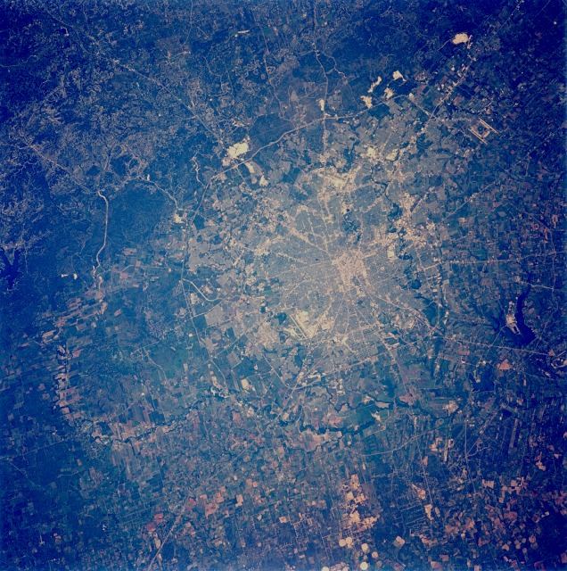 |
| STS050-071-097 San Antonio, Texas, U.S.A. June 1992 San Antonio, Texas, one of the dynamic Sun Belt cities of the United States, is shown in this near-vertical, cloud-free photograph. In addition to the downtown central business district and the grid street pattern of this fast-growing urban area, an extensive highway network is visible in the photograph. Two distinct "loop" highways can be seen encircling the city--the inner loop (Interstate Highway 410) has an average radius of 7 miles (11 kilometers) from the central business district, and the outer loop (Highway 1604) has an average radius of 12 miles (19 kilometers). Interstate Highway 10 radiates eastward and northward; Interstate Highway 35 radiates to the northeast and southwest. San Antonio was founded around permanent springs that rise at the foot of the Balcones Escarpment, which separates the Texas Hill Country from the South Texas Plains. Limestone quarries (highly reflective areas on the northeast side outside Highway 1604) are visible along the edge of the escarpment. San Antonio is a major location for military training bases: Randolph Air Force Base is on the northeast edge of the city between Interstate Highway 35 and Interstate Highway 10; Fort Sam Houston is located within the northeast quadrant of the city inside the outer loop; Brooks Air Force Base is located in the southeast corner of the city inside Interstate Highway 410; and Lackland Air Force Base and Kelly Air Force Base are within the suburban fringe southwest of downtown. San Antonio International Airport can be seen in the northern part of the city between Interstate Highway 410 and Highway 1604. The Medina River, which originates in the Texas Hill Country west of San Antonio, can be seen meandering around the western and southern fringes of this large metropolitan area. Distinct field patterns south of the city show an area used primarily for agriculture. This sharp, cloud free view of San Antonio, Texas (29.5N, 98.5W) illustrates the classic pattern of western cities. The city has a late nineteenth century Anglo grid pattern overlaid onto an earlier, less regular Hispanic settlement. A well marked central business district having streets laid out north/south and east/west is surrounded by blocks of suburban homes and small businesses set between the older colonial radial transportation routes. |
| Images: | All Available Images Low-Resolution 218k |
|
| Mission: | STS050 |
|
| Roll - Frame: | 71 - 97 |
|
| Geographical Name: | USA-TEXAS |
|
| Features: | SAN ANTONIO AREA |
|
| Center Lat x Lon: | 29.5N x 98.5W |
|
| Film Exposure: | N | N=Normal exposure, U=Under exposed, O=Over exposed, F=out of Focus |
| Percentage of Cloud Cover-CLDP: | 0 |
|
| Camera:: | HB |
|
| Camera Tilt: | 21 | LO=Low Oblique, HO=High Oblique, NV=Near Vertical |
| Camera Focal Length: | 250 |
|
| Nadir to Photo Center Direction: | N | The direction from the nadir to the center point, N=North, S=South, E=East, W=West |
| Stereo?: | Y | Y=Yes there is an adjacent picture of the same area, N=No there isn't |
| Orbit Number: | 2 |
|
| Date: | 19920625 | YYYYMMDD |
| Time: | 174845 | GMT HHMMSS |
| Nadir Lat: | 28.5N |
Latitude of suborbital point of spacecraft |
| Nadir Lon: | 98.2W |
Longitude of suborbital point of spacecraft |
| Sun Azimuth: | 113 | Clockwise angle in degrees from north to the sun measured at the nadir point |
| Space Craft Altitude: | 163 | nautical miles |
| Sun Elevation: | 78 | Angle in degrees between the horizon and the sun, measured at the nadir point |
| Land Views: | ESCARPMENT, HILL, PLATEAU |
|
| Water Views: | RIVER, LAKE |
|
| Atmosphere Views: | |
|
| Man Made Views: | AGRICULTURE, MINING, URBAN AREA |
|
| City Views: | SAN ANTONIO |
|
Photo is not associated with any sequences | ||
| NASA Home Page |
JSC Home Page |
JSC Digital Image Collection |
Earth Science & Remote Sensing |
|
This service is provided by the International Space Station program and the JSC Earth Science & Remote Sensing Unit, ARES Division, Exploration Integration Science Directorate.

|