
Geographic Region: USA-TEXAS
Feature: CORPUS CHRISTI
|
Geographic Region: USA-TEXAS Feature: CORPUS CHRISTI |
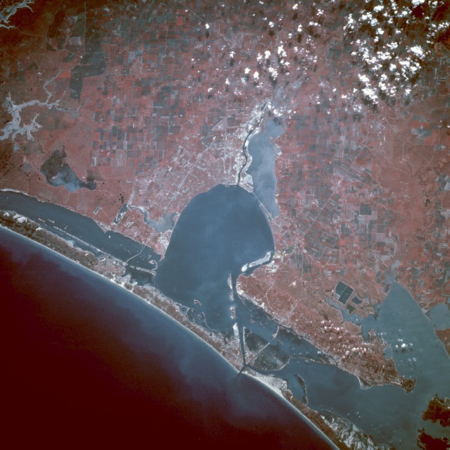 |
| STS049-97-U Corpus Christi, Texas, U.S.A. May 1992 This color infrared southwest-looking, low-oblique photograph emphasizes the blue waters of Corpus Christi Bay and the city of Corpus Christi southwest of the bay. Corpus Christi, with a population of 235 000, is a major petroleum and natural gas center and a port of entry. Major industries include oil refineries, chemicals, cement, aluminum, refined zinc, smelting plants, food processing, and fishing. Tourist and recreational resorts have become a major business on North Padre Island east of the city on the Gulf of Mexico. West of the city, the Nueces River enters Nueces Bay, which, in turn, enters into Corpus Christi Bay. Southeast of the city the runways of the U.S. Naval Air Training Center are seen. West-east Interstate Highway 37 traverses Corpus Christi, crossing Laguna Madre, and terminating on North Padre Island. North-northeast of Corpus Christi Bay are Aransas and Copana Bays. Corpus Christi is subject to occasional hurricanes from the Gulf of Mexico. The last major storm to strike Corpus Christi was Hurricane Celia in 1970. (Refer to STS-026-044-038 for a natural color photograph of the Corpus Christi area.) |
| Images: | All Available Images Low-Resolution 119k |
|
| Mission: | STS049 |
|
| Roll - Frame: | 97 - U |
|
| Geographical Name: | USA-TEXAS |
|
| Features: | CORPUS CHRISTI |
|
| Center Lat x Lon: | 28.0N x 97.5W |
|
| Film Exposure: | N | N=Normal exposure, U=Under exposed, O=Over exposed, F=out of Focus |
| Percentage of Cloud Cover-CLDP: | 10 |
|
| Camera:: | HB |
|
| Camera Tilt: | LO | LO=Low Oblique, HO=High Oblique, NV=Near Vertical |
| Camera Focal Length: | 250 |
|
| Nadir to Photo Center Direction: | The direction from the nadir to the center point, N=North, S=South, E=East, W=West |
|
| Stereo?: | Y | Y=Yes there is an adjacent picture of the same area, N=No there isn't |
| Orbit Number: | |
|
| Date: | 19920512 | YYYYMMDD |
| Time: | GMT HHMMSS |
|
| Nadir Lat: | N |
Latitude of suborbital point of spacecraft |
| Nadir Lon: | E |
Longitude of suborbital point of spacecraft |
| Sun Azimuth: | Clockwise angle in degrees from north to the sun measured at the nadir point |
|
| Space Craft Altitude: | nautical miles |
|
| Sun Elevation: | Angle in degrees between the horizon and the sun, measured at the nadir point |
|
| Land Views: | COAST, ISLAND, PLAIN |
|
| Water Views: | BAY, CHANNEL, SWAMP, ESTUARY |
|
| Atmosphere Views: | |
|
| Man Made Views: | URBAN AREA, AIRPORT, AGRICULTURE |
|
| City Views: | CORPUS CHRISTI |
|
Photo is not associated with any sequences | ||
| NASA Home Page |
JSC Home Page |
JSC Digital Image Collection |
Earth Science & Remote Sensing |
|
This service is provided by the International Space Station program and the JSC Earth Science & Remote Sensing Unit, ARES Division, Exploration Integration Science Directorate.

|