
Geographic Region: USA-TEXAS
Feature: SAN ANTONIO
|
Geographic Region: USA-TEXAS Feature: SAN ANTONIO |
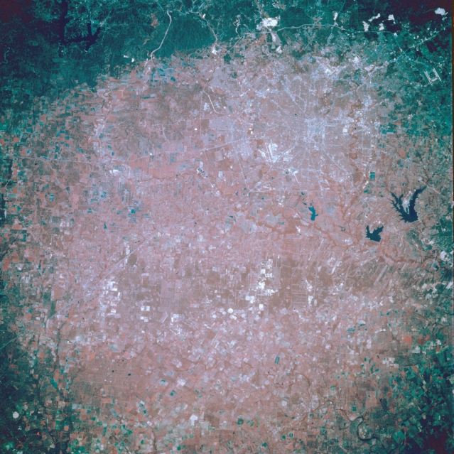 |
| STS049-97-N San Antonio, Texas, U.S.A. May 1992 The outline of urban San Antonio, barely discernible in this color-infrared photograph (upper right quadrant), shows Texas Highway 1604 (the thin line that encircles the northern part of the city) and parts of Interstate Highway 410 (the inner loop, which traverses rolling terrain, especially along the southern edge of the city). Within the center of these highway systems lies the central business district. North of the city (top of photograph) is the dark Balcones fault system (the uplifted balcony) with white spots marking several quarries that produce limestone for cement and road gravel. Visible are three of the city's airports--Randolph Air Force Base with its dual runways (northeast); San Antonio International Airport, north of downtown; and Kelly Air Force Base southwest of downtown--and three lakes south-southeast of the city--large Calaveras Lake; Braunig Lake; and Mitchell Lake, the smallest. Apparent west of the city are rural Medina Valley, a region of rich soils and abundant crops, and the main channel of the Medina River as it loops around and turns eastward, and to the south is the low, rolling topography of sandy soils, sand hills, and mudstone beds. |
| Images: | All Available Images Low-Resolution 386k |
|
| Mission: | STS049 |
|
| Roll - Frame: | 97 - N |
|
| Geographical Name: | USA-TEXAS |
|
| Features: | SAN ANTONIO |
|
| Center Lat x Lon: | 29.5N x 98.5W |
|
| Film Exposure: | N | N=Normal exposure, U=Under exposed, O=Over exposed, F=out of Focus |
| Percentage of Cloud Cover-CLDP: | 5 |
|
| Camera:: | HB |
|
| Camera Tilt: | LO | LO=Low Oblique, HO=High Oblique, NV=Near Vertical |
| Camera Focal Length: | 250 |
|
| Nadir to Photo Center Direction: | The direction from the nadir to the center point, N=North, S=South, E=East, W=West |
|
| Stereo?: | Y | Y=Yes there is an adjacent picture of the same area, N=No there isn't |
| Orbit Number: | |
|
| Date: | 19920512 | YYYYMMDD |
| Time: | GMT HHMMSS |
|
| Nadir Lat: | N |
Latitude of suborbital point of spacecraft |
| Nadir Lon: | E |
Longitude of suborbital point of spacecraft |
| Sun Azimuth: | Clockwise angle in degrees from north to the sun measured at the nadir point |
|
| Space Craft Altitude: | nautical miles |
|
| Sun Elevation: | Angle in degrees between the horizon and the sun, measured at the nadir point |
|
| Land Views: | HILL, ESCARPMENT, RANGE |
|
| Water Views: | RESERVOIR, RIVER |
|
| Atmosphere Views: | |
|
| Man Made Views: | AGRICULTURE, AIRPORT, HIGHWAY, MINING |
|
| City Views: | |
|
Photo is not associated with any sequences | ||
| NASA Home Page |
JSC Home Page |
JSC Digital Image Collection |
Earth Science & Remote Sensing |
|
This service is provided by the International Space Station program and the JSC Earth Science & Remote Sensing Unit, ARES Division, Exploration Integration Science Directorate.

|