Geographic Region: INDONESIA
Feature: LOMBOK, WHOLE ISLAND
|
Geographic Region: INDONESIA Feature: LOMBOK, WHOLE ISLAND |
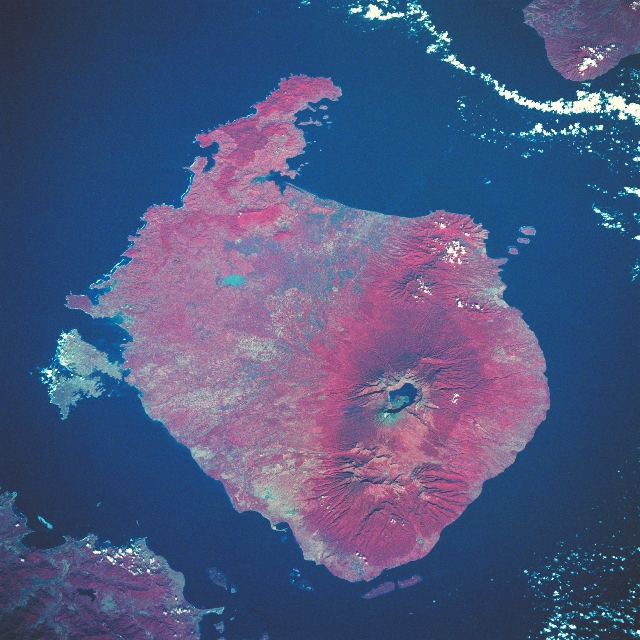 |
| STS049-97-51 Rindjani Volcano, Lombok Island, Indonesia May 1992 The island of Lombok and its major volcano, Rindjani, can be seen in this southwest-looking color infrared view. Lombok Island is 70 miles (113 km) long and 50 miles (81 km) at its widest point. The island covers 2000 sq. miles (5180 sq. km). The varying colors of red show the vegetation zones of the island. The highlands are forest clad and mostly underdeveloped. The lowlands are highly cultivated. Rice, soybeans, coffee, tobacco, cotton, cinnamon, and vanilla are the major crops grown in the fertile soils of the island. The second highest mountain in Indonesia, Rindjani Volcano, at 12224 feet (3726 meters) can be seen on the northern part of the island. Rindjani, a stratovolcano last erupted in 1996. The first historical eruption occurred in September of 1847. The 4-mile (6 km) by 5-mile (8.5 km) oval-shaped caldera is filled partially by a lake known as Segara Anak. The lake, not fully visible due to the shadows from the crater rim, is 754 feet (230 meters) deep. The eruptions of 1994, 1995, and 1996 have formed a small cone in the center of the caldera and lava flows from these eruptions have entered the lake. The Lombok Strait can be seen in the upper right portion of the image. The Alas Strait is visible in the lower left portion of the image. |
| Images: | All Available Images Low-Resolution 369k |
|
| Mission: | STS049 |
|
| Roll - Frame: | 97 - 51 |
|
| Geographical Name: | INDONESIA |
|
| Features: | LOMBOK, WHOLE ISLAND |
|
| Center Lat x Lon: | 8.5S x 116.5E |
|
| Film Exposure: | N | N=Normal exposure, U=Under exposed, O=Over exposed, F=out of Focus |
| Percentage of Cloud Cover-CLDP: | 5 |
|
| Camera:: | HB |
|
| Camera Tilt: | 37 | LO=Low Oblique, HO=High Oblique, NV=Near Vertical |
| Camera Focal Length: | 250 |
|
| Nadir to Photo Center Direction: | SW | The direction from the nadir to the center point, N=North, S=South, E=East, W=West |
| Stereo?: | Y | Y=Yes there is an adjacent picture of the same area, N=No there isn't |
| Orbit Number: | 81 |
|
| Date: | 19920513 | YYYYMMDD |
| Time: | 005413 | GMT HHMMSS |
| Nadir Lat: | 7.4S |
Latitude of suborbital point of spacecraft |
| Nadir Lon: | 118.7E |
Longitude of suborbital point of spacecraft |
| Sun Azimuth: | 60 | Clockwise angle in degrees from north to the sun measured at the nadir point |
| Space Craft Altitude: | 198 | nautical miles |
| Sun Elevation: | 37 | Angle in degrees between the horizon and the sun, measured at the nadir point |
| Land Views: | ISLAND, VOLCANO, FOREST |
|
| Water Views: | |
|
| Atmosphere Views: | |
|
| Man Made Views: | AGRICULTURE |
|
| City Views: | |
|
Photo is not associated with any sequences | ||
| NASA Home Page |
JSC Home Page |
JSC Digital Image Collection |
Earth Science & Remote Sensing |
|
This service is provided by the International Space Station program and the JSC Earth Science & Remote Sensing Unit, ARES Division, Exploration Integration Science Directorate.

|