Geographic Region: INDONESIA
Feature: JAVA, RAUNG VOLCANO
|
Geographic Region: INDONESIA Feature: JAVA, RAUNG VOLCANO |
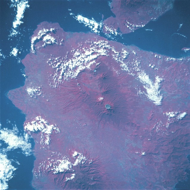 |
| STS049-097-050 Raung Mountain, Indonesia May 1992 The Idjen volcanic plateau on the eastern end of the island of Java (Jawa) appears in this near-vertical color infrared photograph. Impressive Raung Volcano, pinpointed near the center of this photograph, has a very wide caldera surrounded by a grayish rim. The difference in color of the rim and the flanks of the volcanoes is caused by the rim's lack of vegetation compared with the healthy and extensive vegetation on the flanks. Raung, standing almost 11 000 feet (3300 meters) above sea level, is the tallest volcano of this cluster. A well-defined radial drainage pattern emanating from the many volcanic peaks helps identify individual volcanoes. Although the valleys between the major volcanoes boast fertile, ash-enriched soil for agriculture, available land is very limited. The relatively small island of Java has approximately 110 million people, 60 percent of the entire Indonesian population. East across the Strait of Bali lies the western end of the island of Bali. |
| Images: | All Available Images Low-Resolution 132k |
|
| Mission: | STS049 |
|
| Roll - Frame: | 97 - 50 |
|
| Geographical Name: | INDONESIA |
|
| Features: | JAVA, RAUNG VOLCANO |
|
| Center Lat x Lon: | 8S x 114.0E |
|
| Film Exposure: | N | N=Normal exposure, U=Under exposed, O=Over exposed, F=out of Focus |
| Percentage of Cloud Cover-CLDP: | 25 |
|
| Camera:: | HB |
|
| Camera Tilt: | 35 | LO=Low Oblique, HO=High Oblique, NV=Near Vertical |
| Camera Focal Length: | 250 |
|
| Nadir to Photo Center Direction: | W | The direction from the nadir to the center point, N=North, S=South, E=East, W=West |
| Stereo?: | N | Y=Yes there is an adjacent picture of the same area, N=No there isn't |
| Orbit Number: | 81 |
|
| Date: | 19920513 | YYYYMMDD |
| Time: | 005327 | GMT HHMMSS |
| Nadir Lat: | 8.8S |
Latitude of suborbital point of spacecraft |
| Nadir Lon: | 116.2E |
Longitude of suborbital point of spacecraft |
| Sun Azimuth: | 61 | Clockwise angle in degrees from north to the sun measured at the nadir point |
| Space Craft Altitude: | 198 | nautical miles |
| Sun Elevation: | 34 | Angle in degrees between the horizon and the sun, measured at the nadir point |
| Land Views: | ISLAND, VOLCANO, CRATER, PLAIN |
|
| Water Views: | |
|
| Atmosphere Views: | |
|
| Man Made Views: | |
|
| City Views: | |
|
Photo is not associated with any sequences | ||
| NASA Home Page |
JSC Home Page |
JSC Digital Image Collection |
Earth Science & Remote Sensing |
|
This service is provided by the International Space Station program and the JSC Earth Science & Remote Sensing Unit, ARES Division, Exploration Integration Science Directorate.

|