
Geographic Region: SOMALIA
Feature: HAFUN,WATER DYNAMICS
|
Geographic Region: SOMALIA Feature: HAFUN,WATER DYNAMICS |
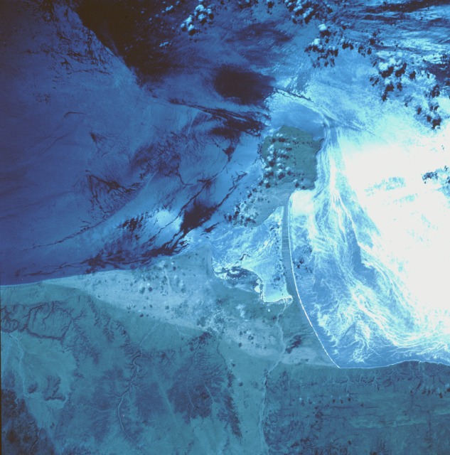 |
| STS049-87-35 Hafun (Raas Xaafuun) Peninsula, Somalia May 1992 This near-vertical, color infrared photograph of the Hafun Peninsula, the eastern extremity of Africa and part of the "Horn of Africa," appears to be complex; however, upon closer inspection, the photograph becomes easier to understand. The highly reflective surface, caused by the Sun reflecting off the surface of the water in Hafun Bay South, enhances the water surface detail (surface roughness and circulation patterns). The darker, less reflective areas in Hafun Bay North provide dynamic surface water information on wave and current patterns. The Hafun Peninsula is a tombolo, a rocky island with a sandy isthmus that connect the island to the mainland. Surface water detail is apparent in the small bay that separates the rocky island from the mainland. Most of the lowland coastal shoreline is composed of sand; yet, a few low beach cliffs--less than 1000 feet (305 meters) in elevation--are observed immediately west of the sandy beach. The reason for the north-south line of color change in some of the beach sand is not known; it might be caused by an elevation change or by differences in moisture content or soil composition of the sand. This entire region is classified as desert. |
| Images: | All Available Images Low-Resolution 121k |
|
| Mission: | STS049 |
|
| Roll - Frame: | 87 - 35 |
|
| Geographical Name: | SOMALIA |
|
| Features: | HAFUN,WATER DYNAMICS |
|
| Center Lat x Lon: | 10.5N x 51.0E |
|
| Film Exposure: | U | N=Normal exposure, U=Under exposed, O=Over exposed, F=out of Focus |
| Percentage of Cloud Cover-CLDP: | 5 |
|
| Camera:: | HB |
|
| Camera Tilt: | 33 | LO=Low Oblique, HO=High Oblique, NV=Near Vertical |
| Camera Focal Length: | 100 |
|
| Nadir to Photo Center Direction: | NE | The direction from the nadir to the center point, N=North, S=South, E=East, W=West |
| Stereo?: | Y | Y=Yes there is an adjacent picture of the same area, N=No there isn't |
| Orbit Number: | 116 |
|
| Date: | 19920515 | YYYYMMDD |
| Time: | 062549 | GMT HHMMSS |
| Nadir Lat: | 9.4N |
Latitude of suborbital point of spacecraft |
| Nadir Lon: | 49.2E |
Longitude of suborbital point of spacecraft |
| Sun Azimuth: | 70 | Clockwise angle in degrees from north to the sun measured at the nadir point |
| Space Craft Altitude: | 193 | nautical miles |
| Sun Elevation: | 56 | Angle in degrees between the horizon and the sun, measured at the nadir point |
| Land Views: | PENINSULA, COAST |
|
| Water Views: | OCEAN, SUNGLINT, SHIP WAKE |
|
| Atmosphere Views: | |
|
| Man Made Views: | |
|
| City Views: | |
|
Photo is not associated with any sequences | ||
| NASA Home Page |
JSC Home Page |
JSC Digital Image Collection |
Earth Science & Remote Sensing |
|
This service is provided by the International Space Station program and the JSC Earth Science & Remote Sensing Unit, ARES Division, Exploration Integration Science Directorate.

|