
Geographic Region: RED SEA
Feature: CURRENTS, WAKE, SUNGLINT
|
Geographic Region: RED SEA Feature: CURRENTS, WAKE, SUNGLINT |
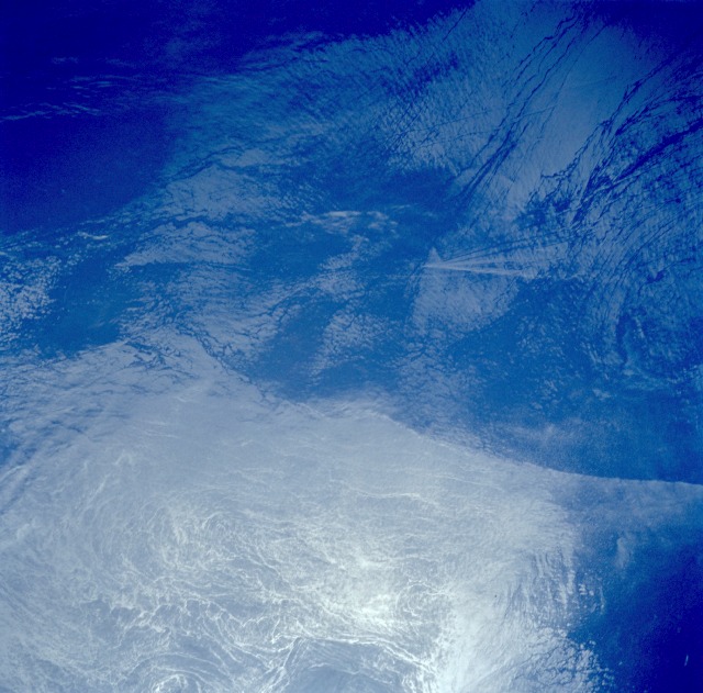 |
| STS049-77-77 Suloy and Ship Wake, Red Sea May 1992 This spectacular, near-vertical photograph clearly shows a suloy in the Red Sea between the Dahlak Archipelago and the Farasan Islands. A suloy is an unusual condition of the sea in which the surface is covered by precipitous and irregular waves that form lines at a boundary. The boundary in this photograph is caused by the flow of water in and out of the Red Sea from the Gulf of Aden through the Strait of Mandeb (Vale of Tears). Little is known about suloys or "lines of chaotic seas," but knowledge increases because of photographs obtained from low-Earth orbit. A ship wake, formed from the bow of a moving ship, is visible as a V-shaped pattern just off center in the dark blue waters. Sun glint, the highly reflective, whitish-gray portion of the photograph, is caused by the sun's reflection from the surface of the sea. Dynamic sea or ocean surface phenomena can be seen in sun glint, especially near the edges where the whitish-gray area becomes some shade of blue. A demarcation line identifies a convergence in the South-Central Red Sea (16.5N, 40.5E) where a suloy (the interface of two ocean currents) has occurred. Photography into the sunglint also highlights many ocean surface features. The phenomenon helps display the different surface roughness, and therefore different reflectivity, across the suloy. A V-shaped ship wake pattern and parts of a spiral eddy and internal waves can also be seen. |
| Images: | All Available Images Low-Resolution 119k |
|
| Mission: | STS049 |
|
| Roll - Frame: | 77 - 77 |
|
| Geographical Name: | RED SEA |
|
| Features: | CURRENTS, WAKE, SUNGLINT |
|
| Center Lat x Lon: | N x E |
|
| Film Exposure: | N | N=Normal exposure, U=Under exposed, O=Over exposed, F=out of Focus |
| Percentage of Cloud Cover-CLDP: | 0 |
|
| Camera:: | HB |
|
| Camera Tilt: | LO=Low Oblique, HO=High Oblique, NV=Near Vertical |
|
| Camera Focal Length: | 250 |
|
| Nadir to Photo Center Direction: | The direction from the nadir to the center point, N=North, S=South, E=East, W=West |
|
| Stereo?: | N | Y=Yes there is an adjacent picture of the same area, N=No there isn't |
| Orbit Number: | 118 |
|
| Date: | 19920515 | YYYYMMDD |
| Time: | 080128 | GMT HHMMSS |
| Nadir Lat: | 16.6N |
Latitude of suborbital point of spacecraft |
| Nadir Lon: | 40.5E |
Longitude of suborbital point of spacecraft |
| Sun Azimuth: | 79 | Clockwise angle in degrees from north to the sun measured at the nadir point |
| Space Craft Altitude: | 192 | nautical miles |
| Sun Elevation: | 72 | Angle in degrees between the horizon and the sun, measured at the nadir point |
| Land Views: | |
|
| Water Views: | SEA, SHIP WAKE, SUNGLINT, SULOY |
|
| Atmosphere Views: | |
|
| Man Made Views: | |
|
| City Views: | |
|
Photo is not associated with any sequences | ||
| NASA Home Page |
JSC Home Page |
JSC Digital Image Collection |
Earth Science & Remote Sensing |
|
This service is provided by the International Space Station program and the JSC Earth Science & Remote Sensing Unit, ARES Division, Exploration Integration Science Directorate.

|