
Geographic Region: DOMINICAN REPUBLIC
Feature: SANTO DOMINGO
|
Geographic Region: DOMINICAN REPUBLIC Feature: SANTO DOMINGO |
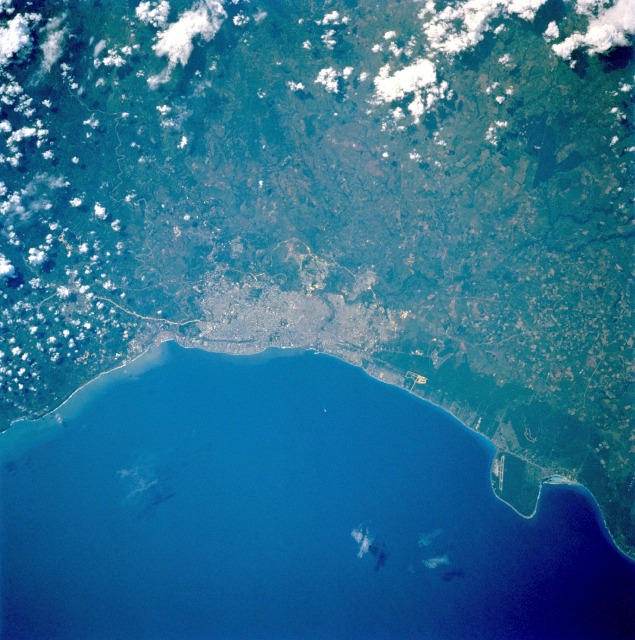 |
| STS049-074-068 Santo Domingo, Dominican Republic May 1992 Santo Domingo, the oldest continuously inhabited settlement in the Western hemisphere, is evident in this near-vertical photograph. The city was founded in 1496 by Christopher Columbus' brother, Bartholomew. Almost destroyed in 1930 by a hurricane, Santo Domingo was rebuilt, and is now a city of broad tree-lined avenues and modern buildings. The cathedral, which was begun in 1514, is the oldest building in the Western Hemisphere and reputedly contains the remains of Christopher Columbus. Located at the mouth of the polluted Ozama River on the coastal plain facing the Caribbean Sea, Santo Domingo is the commercial and cultural center and the principal seaport of the Dominican Republic. Sugar is the chief export; tourism and steel production are major industries. The major runway of the De Las Americas International Airport on Point Caucedo is visible east of the city. |
| Images: | All Available Images Low-Resolution 141k |
|
| Mission: | STS049 |
|
| Roll - Frame: | 74 - 68 |
|
| Geographical Name: | DOMINICAN REPUBLIC |
|
| Features: | SANTO DOMINGO |
|
| Center Lat x Lon: | 18.5N x 70W |
|
| Film Exposure: | N | N=Normal exposure, U=Under exposed, O=Over exposed, F=out of Focus |
| Percentage of Cloud Cover-CLDP: | 5 |
|
| Camera:: | HB |
|
| Camera Tilt: | 21 | LO=Low Oblique, HO=High Oblique, NV=Near Vertical |
| Camera Focal Length: | 100 |
|
| Nadir to Photo Center Direction: | NW | The direction from the nadir to the center point, N=North, S=South, E=East, W=West |
| Stereo?: | Y | Y=Yes there is an adjacent picture of the same area, N=No there isn't |
| Orbit Number: | 14 |
|
| Date: | 19920508 | YYYYMMDD |
| Time: | 190843 | GMT HHMMSS |
| Nadir Lat: | 17.7N |
Latitude of suborbital point of spacecraft |
| Nadir Lon: | 69.5W |
Longitude of suborbital point of spacecraft |
| Sun Azimuth: | 275 | Clockwise angle in degrees from north to the sun measured at the nadir point |
| Space Craft Altitude: | 150 | nautical miles |
| Sun Elevation: | 53 | Angle in degrees between the horizon and the sun, measured at the nadir point |
| Land Views: | COAST |
|
| Water Views: | SEA |
|
| Atmosphere Views: | |
|
| Man Made Views: | AIRPORT, URBAN AREA |
|
| City Views: | SANTO DOMINGO |
|
Photo is not associated with any sequences | ||
| NASA Home Page |
JSC Home Page |
JSC Digital Image Collection |
Earth Science & Remote Sensing |
|
This service is provided by the International Space Station program and the JSC Earth Science & Remote Sensing Unit, ARES Division, Exploration Integration Science Directorate.

|