Geographic Region: CHAGOS ARCHIPELAGO
Feature: SALOMON IS., BLENHEIM RF
|
Geographic Region: CHAGOS ARCHIPELAGO Feature: SALOMON IS., BLENHEIM RF |
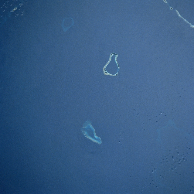 |
| STS049-071-085 Salomon Islands, Chagos Archipelago May 1992 The coral atolls of the Salomon Islands can be seen in this near-nadir view. Part of the Northern Chagos Archipelago, the Salomon Islands are approximately 250 miles (400 km) south of the Maldive Islands in the central Indian Ocean. Blenheim Reef is visible between the bottom center and the center of the image. La Passe, Boddam, and Takamaka Atolls are discernible near the center of the image. Yeye Island is visible near the upper right of the image. All of these atolls are inhabited. |
| Images: | All Available Images Low-Resolution 270k |
|
| Mission: | STS049 |
|
| Roll - Frame: | 71 - 85 |
|
| Geographical Name: | CHAGOS ARCHIPELAGO |
|
| Features: | SALOMON IS., BLENHEIM RF |
|
| Center Lat x Lon: | 5S x 72.5E |
|
| Film Exposure: | N | N=Normal exposure, U=Under exposed, O=Over exposed, F=out of Focus |
| Percentage of Cloud Cover-CLDP: | 0 |
|
| Camera:: | HB |
|
| Camera Tilt: | 33 | LO=Low Oblique, HO=High Oblique, NV=Near Vertical |
| Camera Focal Length: | 250 |
|
| Nadir to Photo Center Direction: | NE | The direction from the nadir to the center point, N=North, S=South, E=East, W=West |
| Stereo?: | Y | Y=Yes there is an adjacent picture of the same area, N=No there isn't |
| Orbit Number: | 5 |
|
| Date: | 19920508 | YYYYMMDD |
| Time: | 065139 | GMT HHMMSS |
| Nadir Lat: | 6.1S |
Latitude of suborbital point of spacecraft |
| Nadir Lon: | 71.2E |
Longitude of suborbital point of spacecraft |
| Sun Azimuth: | Clockwise angle in degrees from north to the sun measured at the nadir point |
|
| Space Craft Altitude: | 159 | nautical miles |
| Sun Elevation: | Angle in degrees between the horizon and the sun, measured at the nadir point |
|
| Land Views: | ATOLL, ISLAND |
|
| Water Views: | REEF |
|
| Atmosphere Views: | |
|
| Man Made Views: | |
|
| City Views: | |
|
Photo is not associated with any sequences | ||
| NASA Home Page |
JSC Home Page |
JSC Digital Image Collection |
Earth Science & Remote Sensing |
|
This service is provided by the International Space Station program and the JSC Earth Science & Remote Sensing Unit, ARES Division, Exploration Integration Science Directorate.

|