Geographic Region: REPUBLIC SOUTH AFRICA
Feature: PHALABORWA, MINING
|
Geographic Region: REPUBLIC SOUTH AFRICA Feature: PHALABORWA, MINING |
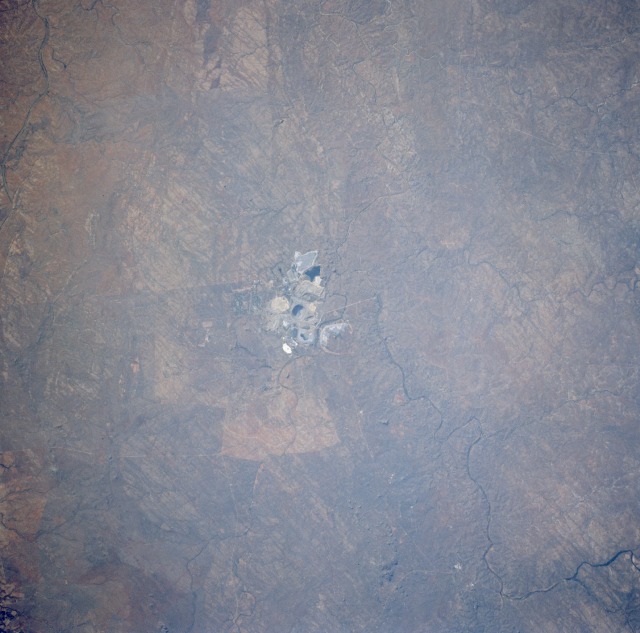 |
| STS049-071-58 Open Pit Mining, Phalaborwa Area, South Africa May 1992 West of Kruger National Park in extreme northeast South Africa are two very large open-pit mining activities. The environmental disturbance to the landscape is quite dramatic in the photograph. The two open-pit mines can be identified by their active mining characteristics--spoil banks or debris piles and water-filled holding or settling ponds. Apparently, both copper and iron ore are mined in this area. The small mining town of Phalaborwa is visible immediately north of the mines. The Olifants River, a tributary to the Limpopo River, flows generally northeastward and passes south of the mining operation. A narrow, highly reflective corridor provides access from the mining site to the Olifants River. Most of the land in this region is used for grazing sheep, cattle, and goats; however, there is some crop production (wheat, maize, and sorghum), especially south of the Olifants River. The overall climate for this area is a transitional zone from a semiarid grassland environment to a more humid temperate climate with a definite dry season during the winter months. |
| Images: | All Available Images Low-Resolution 102k |
|
| Mission: | STS049 |
|
| Roll - Frame: | 71 - 58 |
|
| Geographical Name: | REPUBLIC SOUTH AFRICA |
|
| Features: | PHALABORWA, MINING |
|
| Center Lat x Lon: | 24S x 31.0E |
|
| Film Exposure: | N | N=Normal exposure, U=Under exposed, O=Over exposed, F=out of Focus |
| Percentage of Cloud Cover-CLDP: | 0 |
|
| Camera:: | HB |
|
| Camera Tilt: | 10 | LO=Low Oblique, HO=High Oblique, NV=Near Vertical |
| Camera Focal Length: | 250 |
|
| Nadir to Photo Center Direction: | SW | The direction from the nadir to the center point, N=North, S=South, E=East, W=West |
| Stereo?: | Y | Y=Yes there is an adjacent picture of the same area, N=No there isn't |
| Orbit Number: | 5 |
|
| Date: | 19920508 | YYYYMMDD |
| Time: | 064025 | GMT HHMMSS |
| Nadir Lat: | 23.6S |
Latitude of suborbital point of spacecraft |
| Nadir Lon: | 31.3E |
Longitude of suborbital point of spacecraft |
| Sun Azimuth: | Clockwise angle in degrees from north to the sun measured at the nadir point |
|
| Space Craft Altitude: | 174 | nautical miles |
| Sun Elevation: | Angle in degrees between the horizon and the sun, measured at the nadir point |
|
| Land Views: | PLATEAU, FAULT |
|
| Water Views: | |
|
| Atmosphere Views: | |
|
| Man Made Views: | MINING |
|
| City Views: | |
|
Photo is not associated with any sequences | ||
| NASA Home Page |
JSC Home Page |
JSC Digital Image Collection |
Earth Science & Remote Sensing |
|
This service is provided by the International Space Station program and the JSC Earth Science & Remote Sensing Unit, ARES Division, Exploration Integration Science Directorate.

|