
Geographic Region: AUSTRALIA-WA
Feature: GREAT SANDY DESERT,LAKES
|
Geographic Region: AUSTRALIA-WA Feature: GREAT SANDY DESERT,LAKES |
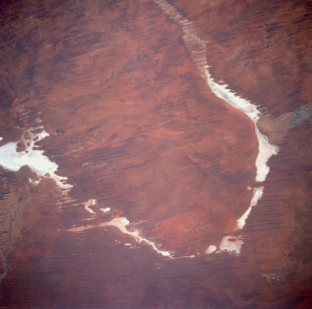 |
| STS048-083-077 Gibson Desert, Australia September 1991 Although western Australia has hundreds of highly reflective dry lakebeds (salt flats), this area offers a unique white "U" chain of dry lakes in this hostile desert environment. Some of the lakes are named--Lake Dora, the larger lake along the western tip of the U, and Lake Auld, the elongated eastern lake. Lake Dora is part of the Rudall River National Park, an isolated park in which scientific studies are encouraged and tourism is discouraged. Located between the Great Sandy Desert to the north and the Gibson Desert to the south, the entire area is characterized by dry sand dunes and sand ridges with some grass and desert vegetation scattered across the landscape. The mottled terrain reflects burn scars caused by range fires that usually result from lightning strikes of severe thunderstorms that infrequently occur in the desert environment. |
| Images: | All Available Images Low-Resolution 105k |
|
| Mission: | STS048 |
|
| Roll - Frame: | 83 - 77 |
|
| Geographical Name: | AUSTRALIA-WA |
|
| Features: | GREAT SANDY DESERT,LAKES |
|
| Center Lat x Lon: | 22.5S x 123.5E |
|
| Film Exposure: | N | N=Normal exposure, U=Under exposed, O=Over exposed, F=out of Focus |
| Percentage of Cloud Cover-CLDP: | 0 |
|
| Camera:: | HB |
|
| Camera Tilt: | 10 | LO=Low Oblique, HO=High Oblique, NV=Near Vertical |
| Camera Focal Length: | 250 |
|
| Nadir to Photo Center Direction: | S | The direction from the nadir to the center point, N=North, S=South, E=East, W=West |
| Stereo?: | N | Y=Yes there is an adjacent picture of the same area, N=No there isn't |
| Orbit Number: | 20 |
|
| Date: | 19910914 | YYYYMMDD |
| Time: | 064928 | GMT HHMMSS |
| Nadir Lat: | 21.7S |
Latitude of suborbital point of spacecraft |
| Nadir Lon: | 123.9E |
Longitude of suborbital point of spacecraft |
| Sun Azimuth: | 288 | Clockwise angle in degrees from north to the sun measured at the nadir point |
| Space Craft Altitude: | 309 | nautical miles |
| Sun Elevation: | 36 | Angle in degrees between the horizon and the sun, measured at the nadir point |
| Land Views: | DESERT, DUNE |
|
| Water Views: | PLAYA |
|
| Atmosphere Views: | |
|
| Man Made Views: | |
|
| City Views: | |
|
Photo is not associated with any sequences | ||
| NASA Home Page |
JSC Home Page |
JSC Digital Image Collection |
Earth Science & Remote Sensing |
|
This service is provided by the International Space Station program and the JSC Earth Science & Remote Sensing Unit, ARES Division, Exploration Integration Science Directorate.

|