
Geographic Region: ATLANTIC OCEAN
Feature: ALPHA 24 ICEBERG
|
Geographic Region: ATLANTIC OCEAN Feature: ALPHA 24 ICEBERG |
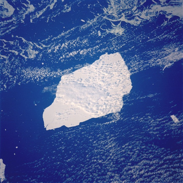 |
| STS048-73-Q Iceberg, South Atlantic Ocean September 1991 A tabular iceberg, which has the outline of a small school bus or small truck and has broken away from the Antarctic ice sheet, is seen in this low-oblique photograph taken just southeast of the tip of South America. Some icebergs in the Southern Hemisphere are more than 62 miles (100 kilometers) long. This iceberg, estimated to be 43 miles (69 kilometers) long and 21 miles (34 kilometers) wide (or about the size of the state of Rhode Island), is moving northeast in the south Atlantic Ocean. Smaller chunks of ice and icebergs can be seen surrounding the larger iceberg. An iceberg of this type and size has never been reported in the Northern Hemisphere. This large tabular iceberg, broken off from the Antarctic Ice Sheet, was spotted in the South Atlantic Ocean (57.0S, 57.0W) southeast of the tip of South America as it was slowly being moved north and east by wind, current and tidal influences. This type of iceberg, never to be seen in the northern hemisphere, is typical for Antarctica. Although some such icebergs are as large as 100 km in length, this one measures about 35 by 69 km. |
| Images: | All Available Images Low-Resolution 162k |
|
| Mission: | STS048 |
|
| Roll - Frame: | 73 - Q |
|
| Geographical Name: | ATLANTIC OCEAN |
|
| Features: | ALPHA 24 ICEBERG |
|
| Center Lat x Lon: | N x E |
|
| Film Exposure: | N | N=Normal exposure, U=Under exposed, O=Over exposed, F=out of Focus |
| Percentage of Cloud Cover-CLDP: | 40 |
|
| Camera:: | HB |
|
| Camera Tilt: | LO | LO=Low Oblique, HO=High Oblique, NV=Near Vertical |
| Camera Focal Length: | 250 |
|
| Nadir to Photo Center Direction: | The direction from the nadir to the center point, N=North, S=South, E=East, W=West |
|
| Stereo?: | N | Y=Yes there is an adjacent picture of the same area, N=No there isn't |
| Orbit Number: | |
|
| Date: | 199109__ | YYYYMMDD |
| Time: | GMT HHMMSS |
|
| Nadir Lat: | N |
Latitude of suborbital point of spacecraft |
| Nadir Lon: | E |
Longitude of suborbital point of spacecraft |
| Sun Azimuth: | Clockwise angle in degrees from north to the sun measured at the nadir point |
|
| Space Craft Altitude: | nautical miles |
|
| Sun Elevation: | Angle in degrees between the horizon and the sun, measured at the nadir point |
|
| Land Views: | |
|
| Water Views: | OCEAN, SEA ICE |
|
| Atmosphere Views: | |
|
| Man Made Views: | |
|
| City Views: | |
|
Photo is not associated with any sequences | ||
| NASA Home Page |
JSC Home Page |
JSC Digital Image Collection |
Earth Science & Remote Sensing |
|
This service is provided by the International Space Station program and the JSC Earth Science & Remote Sensing Unit, ARES Division, Exploration Integration Science Directorate.

|