
Geographic Region: AUSTRALIA-Q
Feature: SHOALWATER BAY,SMOKE,COAST
|
Geographic Region: AUSTRALIA-Q Feature: SHOALWATER BAY,SMOKE,COAST |
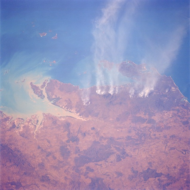 |
| STS048-071-035 Shoalwater Bay, Queensland, Australia September 1991 From time to time, Shuttle-acquired photographs of northeastern Queensland show numerous smoke palls along this coastal region of Australia. These particular fires are burning in the Normanby Range north of the Rockhampton area. This small range of mountains has an average elevation of 1500 feet (450 meters) above sea level, with a few peaks that exceed 2000 feet (600 meters). Visible north of Shoalwater Bay, the small bay east of the mountains, are several small island groups, including the Percy Islands and the Duke Islands. |
| Images: | All Available Images Low-Resolution 93k |
|
| Mission: | STS048 |
|
| Roll - Frame: | 71 - 35 |
|
| Geographical Name: | AUSTRALIA-Q |
|
| Features: | SHOALWATER BAY,SMOKE,COAST |
|
| Center Lat x Lon: | 22.5S x 150.5E |
|
| Film Exposure: | N | N=Normal exposure, U=Under exposed, O=Over exposed, F=out of Focus |
| Percentage of Cloud Cover-CLDP: | 0 |
|
| Camera:: | HB |
|
| Camera Tilt: | 39 | LO=Low Oblique, HO=High Oblique, NV=Near Vertical |
| Camera Focal Length: | 100 |
|
| Nadir to Photo Center Direction: | NE | The direction from the nadir to the center point, N=North, S=South, E=East, W=West |
| Stereo?: | N | Y=Yes there is an adjacent picture of the same area, N=No there isn't |
| Orbit Number: | 4 |
|
| Date: | 19910913 | YYYYMMDD |
| Time: | 051851 | GMT HHMMSS |
| Nadir Lat: | 25.9S |
Latitude of suborbital point of spacecraft |
| Nadir Lon: | 148.4E |
Longitude of suborbital point of spacecraft |
| Sun Azimuth: | 295 | Clockwise angle in degrees from north to the sun measured at the nadir point |
| Space Craft Altitude: | 294 | nautical miles |
| Sun Elevation: | 34 | Angle in degrees between the horizon and the sun, measured at the nadir point |
| Land Views: | COAST, HILL |
|
| Water Views: | BAY, SEDIMENT |
|
| Atmosphere Views: | SMOKE |
|
| Man Made Views: | |
|
| City Views: | |
|
Photo is not associated with any sequences | ||
| NASA Home Page |
JSC Home Page |
JSC Digital Image Collection |
Earth Science & Remote Sensing |
|
This service is provided by the International Space Station program and the JSC Earth Science & Remote Sensing Unit, ARES Division, Exploration Integration Science Directorate.

|