Geographic Region: CHINA
Feature: GOBI DESERT,ALLUVIAL FAN
|
Geographic Region: CHINA Feature: GOBI DESERT,ALLUVIAL FAN |
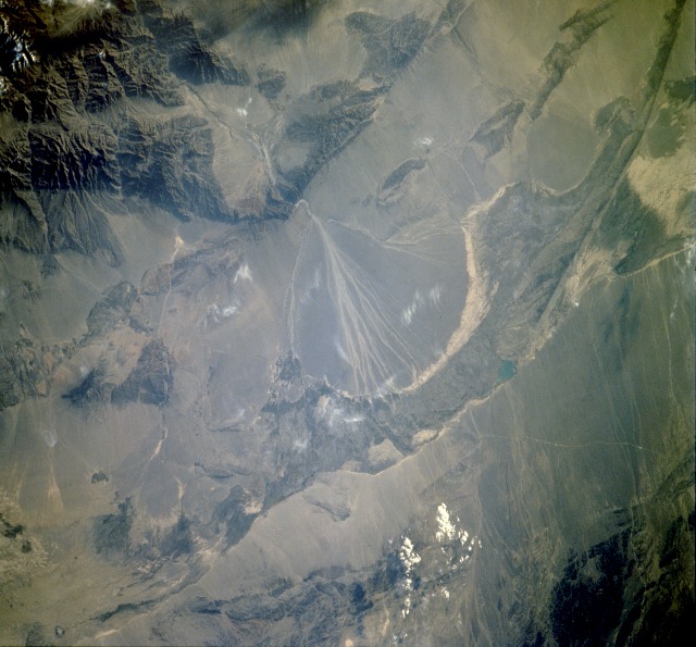 |
| STS048-610-34 Alluvial Fan, Gansu Province, China September 1991 Alluvial fans, cones of sand and gravel, are commonplace in arid-to-semiarid mountain environments. This photograph shows an almost classic alluvial fan, approximately 50 miles (80 kilometers) at its base, west of Yumenzhen in Gansu Province, which borders the southern edge of the Gobi Desert. The northwestern end of the Qilian Mountains is southeast of this large fan. These fans are built by intermittently flowing streams carrying coarse rocks that have been eroded from a mountainous or upland area. Although the braided channels downstream shift constantly, the apex of this fan is fixed at the mouth of a canyon. As the downstream channels switch back and forth, the sweeping action produces the semicircular shape. Near the base of the large fan lies the Hexi Corridor, a narrow ground transportation corridor that contains a road and a railroad whose exact locations are difficult to see because of the scale of the photograph and the lack of contrast in the desert. |
| Images: | All Available Images Low-Resolution 112k |
|
| Mission: | STS048 |
|
| Roll - Frame: | 610 - 34 |
|
| Geographical Name: | CHINA |
|
| Features: | GOBI DESERT,ALLUVIAL FAN |
|
| Center Lat x Lon: | 40.0N x 97.0E |
|
| Film Exposure: | N | N=Normal exposure, U=Under exposed, O=Over exposed, F=out of Focus |
| Percentage of Cloud Cover-CLDP: | 10 |
|
| Camera:: | RX |
|
| Camera Tilt: | 41 | LO=Low Oblique, HO=High Oblique, NV=Near Vertical |
| Camera Focal Length: | 250 |
|
| Nadir to Photo Center Direction: | W | The direction from the nadir to the center point, N=North, S=South, E=East, W=West |
| Stereo?: | Y | Y=Yes there is an adjacent picture of the same area, N=No there isn't |
| Orbit Number: | 68 |
|
| Date: | 19910917 | YYYYMMDD |
| Time: | 102000 | GMT HHMMSS |
| Nadir Lat: | 38.1N |
Latitude of suborbital point of spacecraft |
| Nadir Lon: | 101.0E |
Longitude of suborbital point of spacecraft |
| Sun Azimuth: | 332 | Clockwise angle in degrees from north to the sun measured at the nadir point |
| Space Craft Altitude: | 307 | nautical miles |
| Sun Elevation: | -29 | Angle in degrees between the horizon and the sun, measured at the nadir point |
| Land Views: | MOUNTAIN, DESERT, ESCARPMENT, ALLUVIAL FAN |
|
| Water Views: | |
|
| Atmosphere Views: | |
|
| Man Made Views: | |
|
| City Views: | |
|
Photo is not associated with any sequences | ||
| NASA Home Page |
JSC Home Page |
JSC Digital Image Collection |
Earth Science & Remote Sensing |
|
This service is provided by the International Space Station program and the JSC Earth Science & Remote Sensing Unit, ARES Division, Exploration Integration Science Directorate.

|