
Geographic Region: AUSTRALIA-WA
Feature: EIGHTY MILE BEACH
|
Geographic Region: AUSTRALIA-WA Feature: EIGHTY MILE BEACH |
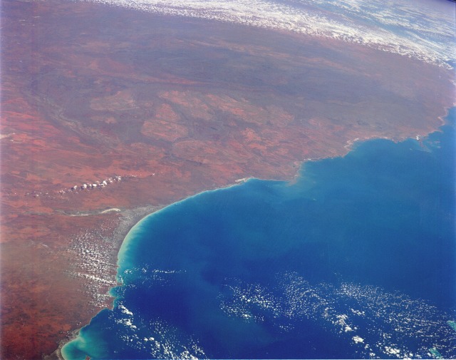 |
| STS048-152-176 Northwest Coast, Western Australia, Australia September 1991 The arid-to-semiarid, reddish-brown landscape characterizes the northwest region of Western Australia. Only major landforms and some interior features are visible in this high-oblique, southwest-looking photograph of the coastal area. The darker, elongated feature near the south portion of the photograph is the Hamersley Range of northwest Australia. Although the Hamersley Range is relatively low--generally less than 4000 feet (1200 meters) above sea level--it is a formidable physical barrier to ground transportation across the region. A considerable amount of iron ore mining takes place in the Pilbara area of northwestern Australia in the Hamersley Range and in the hilly areas between the coast and the mountains. The western edge of the Great Sandy Desert, with its single, narrow line of dry (salt) lakebeds, is visible along the east side of the photograph. The very smooth shoreline is Eighty Mile Beach, just west of which is a sizable delta formed by several north-flowing rivers (most notably, the Shaw and the De Grey). Port Hedland, the major city along this part of the Australian coastline, is barely visible west of the delta. |
| Images: | All Available Images Low-Resolution 84k |
|
| Mission: | STS048 |
|
| Roll - Frame: | 152 - 176 |
|
| Geographical Name: | AUSTRALIA-WA |
|
| Features: | EIGHTY MILE BEACH |
|
| Center Lat x Lon: | 20S x 120.0E |
|
| Film Exposure: | N | N=Normal exposure, U=Under exposed, O=Over exposed, F=out of Focus |
| Percentage of Cloud Cover-CLDP: | 20 |
|
| Camera:: | LH |
|
| Camera Tilt: | HO | LO=Low Oblique, HO=High Oblique, NV=Near Vertical |
| Camera Focal Length: | 250 |
|
| Nadir to Photo Center Direction: | SW | The direction from the nadir to the center point, N=North, S=South, E=East, W=West |
| Stereo?: | Y | Y=Yes there is an adjacent picture of the same area, N=No there isn't |
| Orbit Number: | 36 |
|
| Date: | 19910915 | YYYYMMDD |
| Time: | 065231 | GMT HHMMSS |
| Nadir Lat: | 13.2S |
Latitude of suborbital point of spacecraft |
| Nadir Lon: | 124.3E |
Longitude of suborbital point of spacecraft |
| Sun Azimuth: | 271 | Clockwise angle in degrees from north to the sun measured at the nadir point |
| Space Craft Altitude: | 306 | nautical miles |
| Sun Elevation: | 29 | Angle in degrees between the horizon and the sun, measured at the nadir point |
| Land Views: | COAST, DESERT, RANGE |
|
| Water Views: | |
|
| Atmosphere Views: | |
|
| Man Made Views: | |
|
| City Views: | |
|
Photo is not associated with any sequences | ||
| NASA Home Page |
JSC Home Page |
JSC Digital Image Collection |
Earth Science & Remote Sensing |
|
This service is provided by the International Space Station program and the JSC Earth Science & Remote Sensing Unit, ARES Division, Exploration Integration Science Directorate.

|