
Geographic Region: AUSTRALIA-Q
Feature: GREAT ARTESIAN BASIN
|
Geographic Region: AUSTRALIA-Q Feature: GREAT ARTESIAN BASIN |
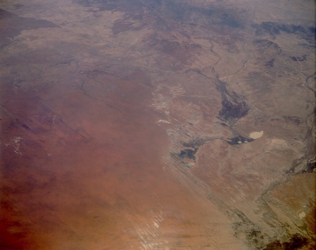 |
| STS048-152-149 Eastern Simpson Desert, Queensland and Northern Territory, Australia September 1991 Ephemeral drainage features abound in this low-oblique, generally north-looking photograph of the eastern Simpson Desert. The western half of the photograph shows numerous sand ridges and northwest-southeast-oriented sand dunes with a reddish-brown appearance caused by a red iron oxide coating on the quartz sands. The eastern half of the photograph shows a complex network of interior drainage patterns. Many watercourses, among them the Eyre River, Georgina River, and Burke River, contain water only when rains occur in the desert. Because of the low relief throughout the region, stream channels alter their courses and create wide floodplains after rains. Some stream channels also seem to be controlled by the prevailing northwest-to-southeast wind. The darker areas within many of the broader floodplains indicate that some type of desert vegetation (usually grasses or algae) is growing in the watercourses. Several mapped dry lakes appear to have water in them, suggesting that recent rains may have provided some moisture to the area. Several lakes are discernible--Lake Machattie, the whitish, roughly oval, water-filled lake toward the east; Lakes Mipia and Koolivoo, the two smaller lakes southwest of Lake Machattie; and a series of elongated, dry salt lakes along the southern edge of the photograph. |
| Images: | All Available Images Low-Resolution 66k |
|
| Mission: | STS048 |
|
| Roll - Frame: | 152 - 149 |
|
| Geographical Name: | AUSTRALIA-Q |
|
| Features: | GREAT ARTESIAN BASIN |
|
| Center Lat x Lon: | 25S x 140.0E |
|
| Film Exposure: | N | N=Normal exposure, U=Under exposed, O=Over exposed, F=out of Focus |
| Percentage of Cloud Cover-CLDP: | 0 |
|
| Camera:: | LH |
|
| Camera Tilt: | 52 | LO=Low Oblique, HO=High Oblique, NV=Near Vertical |
| Camera Focal Length: | 250 |
|
| Nadir to Photo Center Direction: | NE | The direction from the nadir to the center point, N=North, S=South, E=East, W=West |
| Stereo?: | N | Y=Yes there is an adjacent picture of the same area, N=No there isn't |
| Orbit Number: | 34 |
|
| Date: | 19910915 | YYYYMMDD |
| Time: | 051050 | GMT HHMMSS |
| Nadir Lat: | 30.4S |
Latitude of suborbital point of spacecraft |
| Nadir Lon: | 136.4E |
Longitude of suborbital point of spacecraft |
| Sun Azimuth: | 285 | Clockwise angle in degrees from north to the sun measured at the nadir point |
| Space Craft Altitude: | 309 | nautical miles |
| Sun Elevation: | 39 | Angle in degrees between the horizon and the sun, measured at the nadir point |
| Land Views: | DESERT, DUNE |
|
| Water Views: | RIVER |
|
| Atmosphere Views: | |
|
| Man Made Views: | |
|
| City Views: | |
|
Photo is not associated with any sequences | ||
| NASA Home Page |
JSC Home Page |
JSC Digital Image Collection |
Earth Science & Remote Sensing |
|
This service is provided by the International Space Station program and the JSC Earth Science & Remote Sensing Unit, ARES Division, Exploration Integration Science Directorate.

|