
Geographic Region: AUSTRALIA-Q
Feature: NORTHUMBERLAND ISLANDS
|
Geographic Region: AUSTRALIA-Q Feature: NORTHUMBERLAND ISLANDS |
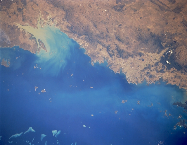 |
| STS048-151-252 Broad Sound Area, Queensland, Australia September 1991 A large sediment plume (light-colored, water borne material) is flowing northward out of the V-shaped Broad Sound along this section of the northeast coast of Queensland. In addition to the obvious sediment plume from Broad Sound, there appears to be a lighter colored, fainter swath of suspended particles located in the Capricorn Channel midway between the mainland and the Great Barrier Reef (part of which is visible in the lower left corner of the image). Three different groups of islands can be seen along this section of Queensland coastline. From northwest to southeast these island groups are Cumberland Islands, Northumberland Islands and the Percy Islands. The darker landscapes away from the coast are low, forested mountains. |
| Images: | All Available Images Low-Resolution 228k |
|
| Mission: | STS048 |
|
| Roll - Frame: | 151 - 252 |
|
| Geographical Name: | AUSTRALIA-Q |
|
| Features: | NORTHUMBERLAND ISLANDS |
|
| Center Lat x Lon: | 21.5S x 149.5E |
|
| Film Exposure: | N | N=Normal exposure, U=Under exposed, O=Over exposed, F=out of Focus |
| Percentage of Cloud Cover-CLDP: | 0 |
|
| Camera:: | LH |
|
| Camera Tilt: | 11 | LO=Low Oblique, HO=High Oblique, NV=Near Vertical |
| Camera Focal Length: | 250 |
|
| Nadir to Photo Center Direction: | SE | The direction from the nadir to the center point, N=North, S=South, E=East, W=West |
| Stereo?: | Y | Y=Yes there is an adjacent picture of the same area, N=No there isn't |
| Orbit Number: | 19 |
|
| Date: | 19910914 | YYYYMMDD |
| Time: | 051346 | GMT HHMMSS |
| Nadir Lat: | 20.7S |
Latitude of suborbital point of spacecraft |
| Nadir Lon: | 148.9E |
Longitude of suborbital point of spacecraft |
| Sun Azimuth: | 288 | Clockwise angle in degrees from north to the sun measured at the nadir point |
| Space Craft Altitude: | 309 | nautical miles |
| Sun Elevation: | 36 | Angle in degrees between the horizon and the sun, measured at the nadir point |
| Land Views: | PENINSULA, ISLAND, MOUNTAIN |
|
| Water Views: | SEDIMENT, BAY, CHANNEL, REEF |
|
| Atmosphere Views: | |
|
| Man Made Views: | |
|
| City Views: | |
|
Photo is not associated with any sequences | ||
| NASA Home Page |
JSC Home Page |
JSC Digital Image Collection |
Earth Science & Remote Sensing |
|
This service is provided by the International Space Station program and the JSC Earth Science & Remote Sensing Unit, ARES Division, Exploration Integration Science Directorate.

|