
Geographic Region: USA-MONTANA
Feature: LARGE STRIPMINING OPNS.
|
Geographic Region: USA-MONTANA Feature: LARGE STRIPMINING OPNS. |
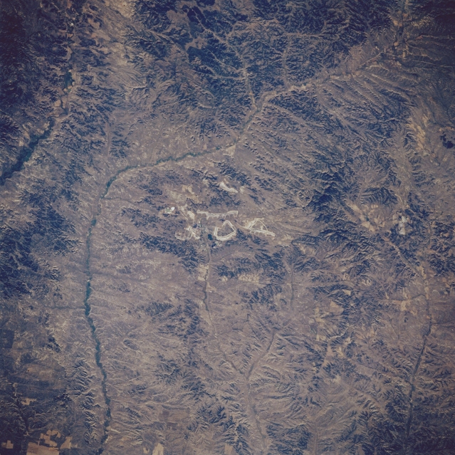 |
| STS047-094-035 Colstrip, Montana, U.S.A. September 1992 Mining operations in Colstrip are featured in this south-looking, low-oblique photograph. Rosebud Creek lies east of the strip mining operations where subbituminous coal is produced. Strip mining for coal, which flourished here during the 1920s, faded because of competition from cheap oil and natural gas. With new laws for land reclamation increasing the demand for power and diminishing reserves of oil and gas, a revival of strip mining occurred during the late 1960s. Highly developed Montana laws and state-of-the-art mine reclamation procedures make recently worked sites visible only to a trained eye; however, landscapes devastated by early strip mining operations remain scattered throughout Montana and other states. |
| Images: | All Available Images Low-Resolution 394k |
|
| Mission: | STS047 |
|
| Roll - Frame: | 94 - 35 |
|
| Geographical Name: | USA-MONTANA |
|
| Features: | LARGE STRIPMINING OPNS. |
|
| Center Lat x Lon: | 46.0N x 107W |
|
| Film Exposure: | U | N=Normal exposure, U=Under exposed, O=Over exposed, F=out of Focus |
| Percentage of Cloud Cover-CLDP: | 0 |
|
| Camera:: | HB |
|
| Camera Tilt: | 27 | LO=Low Oblique, HO=High Oblique, NV=Near Vertical |
| Camera Focal Length: | 250 |
|
| Nadir to Photo Center Direction: | SW | The direction from the nadir to the center point, N=North, S=South, E=East, W=West |
| Stereo?: | Y | Y=Yes there is an adjacent picture of the same area, N=No there isn't |
| Orbit Number: | 50 |
|
| Date: | 19920915 | YYYYMMDD |
| Time: | 163219 | GMT HHMMSS |
| Nadir Lat: | 46.9N |
Latitude of suborbital point of spacecraft |
| Nadir Lon: | 105.9W |
Longitude of suborbital point of spacecraft |
| Sun Azimuth: | 134 | Clockwise angle in degrees from north to the sun measured at the nadir point |
| Space Craft Altitude: | 169 | nautical miles |
| Sun Elevation: | 37 | Angle in degrees between the horizon and the sun, measured at the nadir point |
| Land Views: | HILL |
|
| Water Views: | |
|
| Atmosphere Views: | |
|
| Man Made Views: | MINING |
|
| City Views: | |
|
Photo is not associated with any sequences | ||
| NASA Home Page |
JSC Home Page |
JSC Digital Image Collection |
Earth Science & Remote Sensing |
|
This service is provided by the International Space Station program and the JSC Earth Science & Remote Sensing Unit, ARES Division, Exploration Integration Science Directorate.

|