Geographic Region: USA-ALASKA
Feature: ALEUTIAN IS., UNIMAK I.
|
Geographic Region: USA-ALASKA Feature: ALEUTIAN IS., UNIMAK I. |
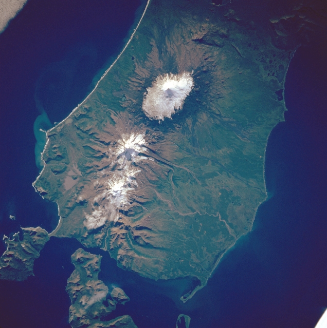 |
| STS047-081-025 Unimak Island and Aleutian Islands, Alaska, U.S.A. September 1992 Three distinctive, snowcapped stratovolcanoes are easily identified in this near-vertical photograph of Unimak Island, one of many volcanic islands in the Aleutian archipelago. The Aleutian archipelago, formed by the collision of the Pacific Plate with the western extension of the North American Plate, forms a northern part of the Ring of Fire that encircles the Pacific Ocean. Unimak Island, the large island nearest the Alaskan Peninsula, is separated from the peninsula by Bechevin Bay, shown at the bottom of the photograph. Shishaldin Volcano, the westernmost and tallest of the three featured volcanoes, reaches a maximum elevation of 9387 feet (2860 meters) above sea level and has been very active during the last two centuries, especially during the mid-1900s. Isanolski Volcano, the middle volcano, climbs to 8088 feet (2465 meters) above sea level. Each of these volcanoes exhibits a classic erosional drainage pattern that radiates in all directions from the central peak. |
| Images: | All Available Images Low-Resolution 305k |
|
| Mission: | STS047 |
|
| Roll - Frame: | 81 - 25 |
|
| Geographical Name: | USA-ALASKA |
|
| Features: | ALEUTIAN IS., UNIMAK I. |
|
| Center Lat x Lon: | 55.0N x 164W |
|
| Film Exposure: | N | N=Normal exposure, U=Under exposed, O=Over exposed, F=out of Focus |
| Percentage of Cloud Cover-CLDP: | 0 |
|
| Camera:: | HB |
|
| Camera Tilt: | 9 | LO=Low Oblique, HO=High Oblique, NV=Near Vertical |
| Camera Focal Length: | 250 |
|
| Nadir to Photo Center Direction: | S | The direction from the nadir to the center point, N=North, S=South, E=East, W=West |
| Stereo?: | Y | Y=Yes there is an adjacent picture of the same area, N=No there isn't |
| Orbit Number: | 24 |
|
| Date: | 19920914 | YYYYMMDD |
| Time: | 012752 | GMT HHMMSS |
| Nadir Lat: | 55.4N |
Latitude of suborbital point of spacecraft |
| Nadir Lon: | 164.2W |
Longitude of suborbital point of spacecraft |
| Sun Azimuth: | 227 | Clockwise angle in degrees from north to the sun measured at the nadir point |
| Space Craft Altitude: | 171 | nautical miles |
| Sun Elevation: | 29 | Angle in degrees between the horizon and the sun, measured at the nadir point |
| Land Views: | ISLAND, VOLCANO |
|
| Water Views: | BAY |
|
| Atmosphere Views: | |
|
| Man Made Views: | |
|
| City Views: | |
|
Photo is not associated with any sequences | ||
| NASA Home Page |
JSC Home Page |
JSC Digital Image Collection |
Earth Science & Remote Sensing |
|
This service is provided by the International Space Station program and the JSC Earth Science & Remote Sensing Unit, ARES Division, Exploration Integration Science Directorate.

|