
Geographic Region: KAZAKHSTAN
Feature: ARAL SEA
|
Geographic Region: KAZAKHSTAN Feature: ARAL SEA |
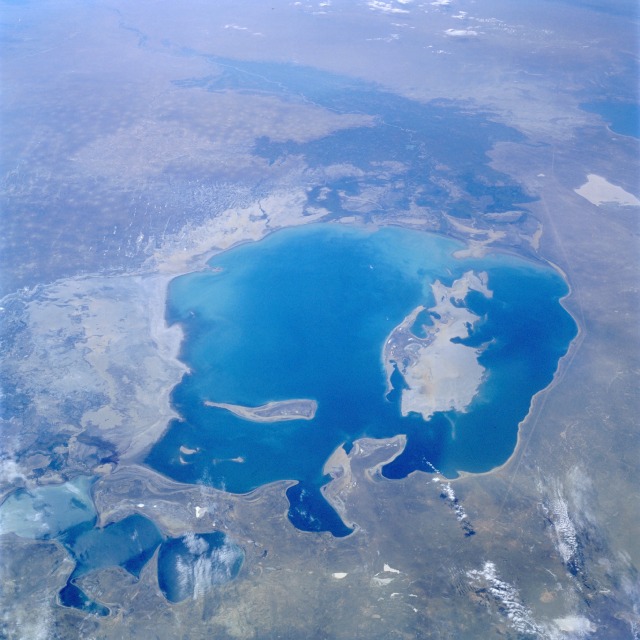 |
| STS047-079-083 Aral Sea, Kazakhstan and Uzbekistan September 1992 A much depleted Aral Sea (refer to the July 1985 photograph STS-51F-036-0059) can be seen in this south-looking, low-oblique view. The emerging, pointed island of Barsa-Kel'mes and the expanding, broad Vozrozhdeniya Island are visible in the center of the sea. Vozrozhdeniya Island is expanding southward toward the Amu Darya River Delta and northward toward the growing Kulandy Peninsula. Continued shrinkage of the Aral Sea water levels will eventually cut off the western portion from the rest of the sea. This phenomenon has already occurred in the extreme northern portion of the sea. Because of dropping water levels, the Karatyup Peninsula (the stretch of land visible north of the main portion of the Aral Sea) has expanded eastward and connected with the delta of the Syr Darya River, cutting off the extreme northern portion from the larger main area of the Aral Sea. With no river inlet into this extreme north portion, it is only a matter of time before this area is reduced to a series of smaller lakes. East of the sea, more exposed shoreline is visible (whitish-gray). It is estimated that the Aral Sea water level has decreased 46 percent since 1960 and is continuing to decrease. The darker areas to the south are the irrigated agricultural lands of the Amu Darya River. |
| Images: | All Available Images Low-Resolution 101k |
|
| Mission: | STS047 |
|
| Roll - Frame: | 79 - 83 |
|
| Geographical Name: | KAZAKHSTAN |
|
| Features: | ARAL SEA |
|
| Center Lat x Lon: | 45.0N x 60.0E |
|
| Film Exposure: | N | N=Normal exposure, U=Under exposed, O=Over exposed, F=out of Focus |
| Percentage of Cloud Cover-CLDP: | 0 |
|
| Camera:: | HB |
|
| Camera Tilt: | LO | LO=Low Oblique, HO=High Oblique, NV=Near Vertical |
| Camera Focal Length: | 100 |
|
| Nadir to Photo Center Direction: | S | The direction from the nadir to the center point, N=North, S=South, E=East, W=West |
| Stereo?: | Y | Y=Yes there is an adjacent picture of the same area, N=No there isn't |
| Orbit Number: | 43 |
|
| Date: | 19920915 | YYYYMMDD |
| Time: | 055918 | GMT HHMMSS |
| Nadir Lat: | 49.1N |
Latitude of suborbital point of spacecraft |
| Nadir Lon: | 59.3E |
Longitude of suborbital point of spacecraft |
| Sun Azimuth: | 142 | Clockwise angle in degrees from north to the sun measured at the nadir point |
| Space Craft Altitude: | 169 | nautical miles |
| Sun Elevation: | 37 | Angle in degrees between the horizon and the sun, measured at the nadir point |
| Land Views: | DESERT, BASIN, PLATEAU |
|
| Water Views: | LAKE, SEDIMENT, RIVER, DELTA |
|
| Atmosphere Views: | |
|
| Man Made Views: | AGRICULTURE, POLLUTION |
|
| City Views: | |
|
Associated Photos in Sequence:  Photo #: STS51F-36-59 Photo #: STS51F-36-59Description: ARAL SEA-1985; DECREASING LAKE LEVELS Sequence ID: 1A  Photo #: STS047-79-83 ** Currently displayed photo ** Photo #: STS047-79-83 ** Currently displayed photo ** Description: ARAL SEA-1992; DECREASING LAKE LEVELS Sequence ID: 1B  Photo #: STS059-L22-140 Photo #: STS059-L22-140Description: ARAL SEA-1994; DECREASING LAKE LEVELS Sequence ID: 1C | ||
| NASA Home Page |
JSC Home Page |
JSC Digital Image Collection |
Earth Science & Remote Sensing |
|
This service is provided by the International Space Station program and the JSC Earth Science & Remote Sensing Unit, ARES Division, Exploration Integration Science Directorate.

|