Geographic Region: CANADA-NS
Feature: CAPE BRETON ISLAND
|
Geographic Region: CANADA-NS Feature: CAPE BRETON ISLAND |
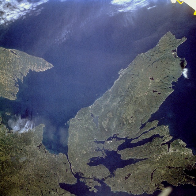 |
| STS047-078-062 Cape Breton Island, Nova Scotia, Canada September 1992 The Canadian maritime province of Nova Scotia can be divided into two separate regions--Cape Breton Island and much larger, peninsular mainland Nova Scotia. Cape Breton Island is joined to the mainland by a causeway and a railroad spanning the narrow Strait of Canso. The small scale of this photograph helps to reveal the fragmented nature and the remoteness of the heavily forested landscape in the northeastern part of Nova Scotia. The Cape Breton Highlands on the larger peninsula that juts into the Gulf of St. Lawrence consist of steep cliffs and a rugged coastline, forming some of the most spectacular scenery in northeastern North America. St. George's Bay is the small bay west of the causeway, and the Northumberland Strait separates Cape Breton Island from the eastern end of Prince Edward Island, another maritime province of Canada (visible along the west margin of the photograph). Chedabucto Bay is the small bay east of the causeway bridges. Bras d'Or Lake is the large body of water in south-central Cape Breton Island, and St. Andrews Channel is the elongated, northeast-southwest-oriented water body north of Bras d'Or Lake. Cape Breton Island is noted for its superb fishing industry, coal mining operations around the city of Sydney, and its tourism industry. The port city of Sydney is visible along a highly reflective inverted Y-shaped inlet near the southeastern edge of the photograph. |
| Images: | All Available Images Low-Resolution 133k |
|
| Mission: | STS047 |
|
| Roll - Frame: | 78 - 62 |
|
| Geographical Name: | CANADA-NS |
|
| Features: | CAPE BRETON ISLAND |
|
| Center Lat x Lon: | 46.0N x 61.5W |
|
| Film Exposure: | N | N=Normal exposure, U=Under exposed, O=Over exposed, F=out of Focus |
| Percentage of Cloud Cover-CLDP: | 0 |
|
| Camera:: | HB |
|
| Camera Tilt: | 40 | LO=Low Oblique, HO=High Oblique, NV=Near Vertical |
| Camera Focal Length: | 100 |
|
| Nadir to Photo Center Direction: | SW | The direction from the nadir to the center point, N=North, S=South, E=East, W=West |
| Stereo?: | N | Y=Yes there is an adjacent picture of the same area, N=No there isn't |
| Orbit Number: | 48 |
|
| Date: | 19920915 | YYYYMMDD |
| Time: | 133117 | GMT HHMMSS |
| Nadir Lat: | 47.1N |
Latitude of suborbital point of spacecraft |
| Nadir Lon: | 59.4W |
Longitude of suborbital point of spacecraft |
| Sun Azimuth: | 134 | Clockwise angle in degrees from north to the sun measured at the nadir point |
| Space Craft Altitude: | 169 | nautical miles |
| Sun Elevation: | 36 | Angle in degrees between the horizon and the sun, measured at the nadir point |
| Land Views: | ISLAND, FOREST, COAST, HILL, PENINSULA |
|
| Water Views: | OCEAN, LAKE, BAY, RIVER, STRAIT |
|
| Atmosphere Views: | |
|
| Man Made Views: | URBAN AREA, AIRPORT, MINING |
|
| City Views: | |
|
Photo is not associated with any sequences | ||
| NASA Home Page |
JSC Home Page |
JSC Digital Image Collection |
Earth Science & Remote Sensing |
|
This service is provided by the International Space Station program and the JSC Earth Science & Remote Sensing Unit, ARES Division, Exploration Integration Science Directorate.

|